


Central Ground Water Board, NER, Guwahati.
INTRODUCTION
Located on the middle of the mighty Brahmaputra River, Majuli Island is regarded as thelargest fresh water river island in the world. The island is formed with the confluence ofBrahmaputra and Lohit rivers. The island also termed as the cultural capital of Assam.
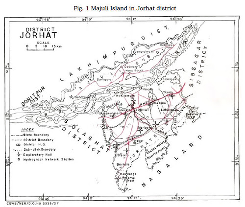 The area is bounded by the N Latitudes 26º 39' 57.6'' and 27º 16' 19.2'' and E Longitudes 93º 34' 12'' and 94º 42' 3.6'' and is covered by the Survey of India toposheet no. 83 F/13, I/4, I/8, I/12, J/1, J/5, J/6 and J/9 (Fig. 1). The river Brahmaputra and its tributary, the Subansiri River forms the boundary of the island on three sides and the Kherkutia Suti, a distributary of Brahmaputra River, forms the fourth side.
AREA AND ACCESSIBILITY
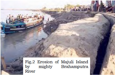
The island was severely affected by erosion since the occurrence of 1950 earthquake. It isreported that the original size of 1,245 sq km is reduced to 577.65 sq km (as evidenced bythe study from the IRS satellite imagery of 1998) due to erosion. At present, the area of the island is reported to be about 422 sq. km. The frequent floods and the consequent erosionhave shattered the Majuli Island (Fig. 2).
It is approachable both from the northern side as well as southern side. The easiest way toapproach the island is from Jorhat, which is very well connected by road (NH - 37), rail andair to Guwahati and other parts of the country.
The climate is characterized by highly humid atmosphere, abundant rainfall and generalcoolness. Average annual rainfall recorded at the Majuli Island is about 1,922 mm. Thealtitude ranges from 40 to 120 m a MSL.
GEOLOGICAL SETTING
 Geologically, the Majuli Island is occupied by unconsolidated alluvial sediments ofQuaternary age. The island forms a part of the vast alluvial plain of Brahmaputra Rivervalley. It was developed by foreland depression lying in between the Himalayanorogenic belt in the north and southern crystalline massifs. The sediments owe its origin and development with the different phases of upliftment, glaciations and erosion of the Himalayas and basement tectonics of crystalline massifs. The newer alluvium is generally confined to topographical lows following the stream courses. These deposits are distinguishable by their characteristic grey colour and generally well sorted alternate layers of clays, silts, sands and gravels.
SUB- SURFACE GEOLOGY
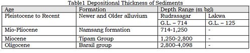
The drilling carried out by ONGC and Oil India Limited for oil and gas in nearby area of theisland in the Brahmaputra valley revealed the thickness of sediments ranges from 4 km toas much as 6.5 km. The bore hole logs of ONGC at Rudrasagar and Lakwa which are about50 km south-east of the island indicate the thickness of Quaternary alluvium as 714 m and1,250 m respectively and the basement at Rudrasagar is 4,098 m bgl .The nature andthickness of sediments encountered in these two locations are given in Table-1.
 In the Island, the CGWB has not carried out any ground water exploration due to theproblems of approachability. Truck mounted rig cannot be transported through water routeto Majuli Island. As such, the disposition of granular zones to the depth of about 300 m bglhas been confirmed based on exploratory well data of CGWB constructed in Jorhat subdivision under similar hydrogeological condition. The granular zones delineated from theexploratory data of the drilling are as follows.
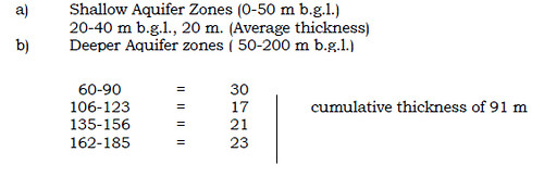
HYDROGEOLOGY
Based on the data available in adjacent area, behavior and occurrence of ground waterbeyond the Island i.e. south of Brahmaputra River bordering the Island, the regional groundwater condition of the area have been grouped under two categories.
a) Shallow aquifer occurring within the depth of 50 m.
b) Deeper aquifer beyond a depth of 50 m and down to 200 m below groundlevel.
a) Shallow Aquifer
The shallow aquifer occurring within a depth of 50 m from the land surface consists of amixture of sand, clay and silt. The thickness of aquifer is about 20 m and ground wateroccurs under unconfined condition. Open wells and shallow tube wells are feasible todevelop ground water for domestic as well as irrigation purposes.
The water table is shallow and rests within 2-4 m b.g.l. during pre-monsoon period and thegeneral fluctuation of water table during pre and post monsoon period is about 2 m. Theflow of ground water almost follows the general topography of the area and towards RiverBrahmaputra. The hydraulic conductivity of 15 to 20 m/day may be expected.
b) Deeper Aquifer
The aquifer occurring in the depth range of 50 to 200 m below ground level is grouped inthis category. The aquifers consist of fine to medium grained sand with clay intercalation.The exploration data revealed presence of four to five major aquifer zones. Ground wateroccurs under confined to semi-confined conditions. The piezometric level rests around 5 mbelow ground level as revealed from the exploratory well at Brahmingaon and Kakajan. Thehydraulic conductivity value of aquifers as 50 m/day may safely be taken for design criteriaof deep tube wells.
CHEMICAL QUALITY OF GROUND WATER
Arsenic Study in Majuli River Island, Jorhat district, Assam
Higher concentration of arsenic (As) in groundwater in the northeastern states of India hasbecome a major cause of concern in recent years. Arsenic (As) in ground water has beenreported from a few parts of Assam and adjoining areas. These areas mostly fall in the vastriverside tracts of the Brahmaputra River. However, reports have also come from BarakRiver valley areas. North-Eastern Regional Institute of Water and Land Management(NERIWALM), based on their own study, claimed that most of the districts of Assam areaffected. Public Health Engineering Department has conducted its own study partly incollaboration with UNICEF, however, detailed findings are yet to be published. Thus, Assamhas been identified as one of the states with As contamination. However, physicalmanifestation of ‘arsenicosis’ has not been observed till date among the people living in thearea.
As per advice of Ministry of Water Resources, a programme was chalked out for sampling inMajuli Island for determination of arsenic content in ground water. As deep tube wells donot exist in Majuli Island at present, it posed a constraint for determination of arseniccontent in ground water in deeper aquifer. Water samples were collected from shallow tubewells/hand pumps within 50 m depth. These samples were analyzed in the RegionalChemical Laboratory, CGWB, ER, Kolkata.
Source, Cause and Toxicity of Arsenic
Arsenic may occur in ground water as a result of mineral dissolution and industrialdischarges containing Arsenic or by the application of Arsenic based pesticides used foragricultural purposes. In Assam, the arsenic contamination problem is mainly due togeological reason. Ground water may contain varying amount of Arsenic compounds of As(III) or As (V). In oxidizing environmental conditions, pentavalent species are more stableand predominant. Whereas in reducing environmental conditions, trivalent species arepredominant. The trivalent compounds are generally more toxic than pentavalentcompounds. The most common compound of Arsenic is the sulphides in the reduced formand Arsenate is in the oxidized form.
The occurrence of Arsenic in ground water is mostly due to leaching of geological minerals,dissolution of unstable Arsenic minerals, chemical transformation within the formation etc.
Alluvial environments are mostly characterized by reducing conditions (anaerobic), whichcause high Arsenic concentrations in ground water. In these environments, aquifersediments do not allow air to enter the aquifer and coupled with the fact that recentsediments contain organic matter which uses available oxygen, result in the development ofreducing conditions. Reducing conditions result in increased concentrations of Arsenic insolution, which are dominated by trivalent Arsenic species. Arsenic contamination may alsobe caused by oxidation of pyrite, arsenopyrite that is present in aquifer sediments, byatmospheric oxygen, which enters ground water. Iron also plays an important role in therelease of arsenic in groundwater. Another factor that can affect arsenic concentrations isthe presence of anions such as bicarbonate, phosphate and sulphate.
However, no specific source of Arsenic has been identified yet. Arsenic fluxes in groundwater depend on redox processes (anaerobic and aerobic). The transport behaviour ofArsenite (As III) and Arsenate (As V) varies significantly on redox condition. In an anaerobicaquatic environment, relatively high Arsenic concentration may occur depending on thelocal geochemical controls.
Trivalent arsenic can be toxic, consequently causing cell damage. Arsenic can interfere withessential enzymatic functions and transcriptional events in cell. Arsenite is known to inhibitmore than 200 enzymes in the body. Because Arsenate has a similar structure asphosphate, it can substitute for phosphorus in the body, which can lead to replacement ofphosphorus in the bone for many years. Arsenate prevents subsequent transfer ofphosphate to adenosine diphosphate (ADP) to form adenosine triphosphate (ATP, the energy currency of the cell) and thus depletes the cell of its energy. It is also known that Arsenic decreases DNA repair process and hence enhances susceptibility to cancer andnoncancerous diseases. Prolonged consumption of arseniferous ground water may result inlarge-scale health hazard in the concerned region due to symptoms of arsenicosis, skinlesions, hyperkeratosis, melanosis as well as other types of carcinogenic manifestations.
RESULTS AND DISCUSSION
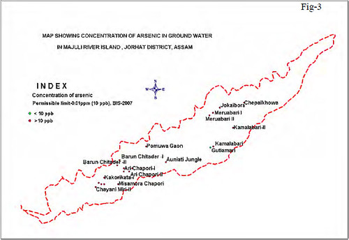
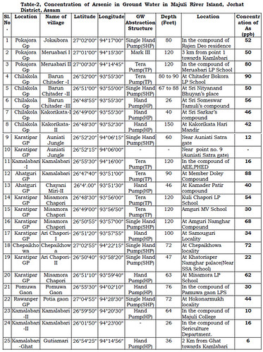
Twenty-four ground water samples were collected from shallow ground water abstractionstructures mainly tube wells and were analyzed for arsenic concentration. Results of thechemical analysis of the samples are given in Table-2. The location of the sampling stationsand arsenic content has been shown in Plate-I. The range of arsenic in the area is from 6-90 ppb. Concentration of arsenic has been found beyond permissible limit (Permissiblelimit-10 ppb, BIS, 2007) at all locations except the locations of Kamalabari Ghat andGutiamari.
However physical manifestation of arsenic effect has not been reported in the area. Somesalient points regarding chemical analysis of water samples are given below.
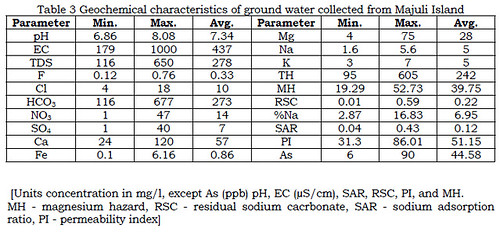
1. The pH of the analyzed samples varies from 6.86 to 8.08. In general, pH of watersamples was neutral to slightly alkaline in nature.
2. EC values vary from 179 to 1000 μScm-1 at 25 0C.
3. Bicarbonate contributes an average of 89% to the total anions followed by chloride(7%) with minor contribution from nitrate, sulphate and fluoride.
4. The phosphate concentration varied between 0.1 to 1.09 mg/l. The averagephosphate value was 0.34 mg/l.
5. The range of Iron in the area is from 0.012-6.16 mg/l. The analytical data showsthat Fe exceeds the safe limit in about 50% of the sample.
Geochemical characteristics of ground water collected from Majuli Island are shown inTable 3.
Map (Not in Scale)
CONCLUSIONS AND RECOMMENDATIONS
Conclusions
From the analysis of ground water samples collected from shallow depth (50 m), it is foundthat out of 24 samples analyzed, all have shown Arsenic content more than 10 ppb exceptone sample. Highly silty nature of sediments prevails in shallow depth. Arsenic content inground water in deeper aquifers could not be assessed because no deep tube well exists inthe Island. There is not a single case of physical manifestation in the human body contraryto be observation in the neighboring states. The reason may be attributed to the practice oflocal people to use indigenous filters to filter ground water before drinking and domesticuse. Arsenic probably precipitates out along with iron to some extent in the above process.
Recommendations
i. Deeper aquifers should be explored.
ii. Ground water of deeper aquifers should be analyzed for assessment of hazardouselement like arsenic, fluoride etc.
iii. Alternate sources of drinking water should be studied and prioritized.
iv. Awareness campaigns about health hazards due to intake of excessive Arsenic arethe need of the time.
v. Geophysical resistivity survey to determine the sub-surface lithology.
vi. Sampling of lithology (through manual boring) up to 50 m depth should be done forstudying the correlation and depositional trend of sediments.
vii. Role of pesticides used for agricultural activity should be carefully observed.
Acknowledgement
The authors are thankful to Chairman, Member (SML), Member (SAM), Regional Director(NER), Central Ground Water Board for kindly permitting the authors to publish this paper.
Posted by


