


ABSTRACT
Garur-Baijnath area falls in Garur Valley, Bageshwar District. Geologically, the area is represented by the Lesser Himalayan Tectonic Zone. Hydrogeology of the area is complex owing to the structural and tectonic settings, characterized by multiple phases of deformation and high-grade metamorphism. Cold-water springs are the primary source for drinking and domestic use for the local populace. Hand pumps constructed by Uttarakhand Jal Sansthan also form additional source of drinking water supply. Small irrigational canals (Guls), storage tanks (Hauj) and lift irrigation schemes (Hydrums) are water sources for agriculture and irrigation purposes both during monsoon and non-monsoon periods. Hydrogeologicalstudies in parts of Garur Valley have shown that discharge of springs has been reduced over the years and the existing water supply schemes are inadequate as far as the needs of the local people are concerned. The possibility of large-scale groundwater development in Garur Valley is negligible but small to moderate development is feasible through renovation of spring-based water supply schemes and construction of tube wells after proper hydrogeological investigations followed by groundwater exploration. Hydrochemistry ofground water from seepages and hand pumps indicate that quality of groundwater is excellent for irrigational and drinking purposes. However, high nitrate and fluoride are observed in isolated pockets of Garur Valley. The high nitrate is attributable to anthropogenic sources whereas the high fluoride is due to the geogenic source.
Keywords: Garur Valley, nitrate, fluoride, hydrochemistry, anthropogenic, geogenic
INTRODUCTION
Hydrogeological and hydrochemical studies are concentrated in an area of about 50 km2 in the Garur Valley, around Garur and Baijnath. The Garur Valley is named after Garur, the block headquarter and an important hub for trading and commercial activities in Bageshwar district. The study area falls between north latitudes 29º50' and 29º59'; east longitudes 79º34' and 79º42'. Garur Valley has the most fertile land in the entire Bageshwar district and exhibits a typical U-shaped profile characteristic of glaciations, which has been incised in the lower portioninto V-shape by the river action. The area forms part of Lesser Himalayan Zone and has a highly undulating topography. The general elevation lies between 1200 and 1500 m amsl. The area is drained by the perennial rivers Gomti and Garur Ganga along with their tributaries like Ghanghali Gadhera, Latoliya Gadhera and Mate Gad, whichare seasonal. The area experiences a sub-tropical to temperate climate having mean minimum and mean maximum temperatures of 5ºC and 35ºC respectively. Agriculture is the principal source of employment for the local populace, followed by animal husbandry. Due to high production of rice, the Garur Valley is also known as “Rice Bowl of Kumaun”.
Systematic hydrogeological surveys were carried out in parts of the area by Central Ground Water Board (e. g. Venkatesan and Bhattacharya, Bhattacharya) during the period 1975-79 and brought out as unpublished reports (Zaidi, 1996). However, for the first time, data on spring discharge and drilled depth and discharge of India Mark-II hand pumps were analysed. Hydrogeological study in the area shows that groundwater scenario in the hilly tracts is quite different from the valley portions of Gomti River which is the major perennial river flowing along the Garur Valley. Scarcity of lift schemes and accessibility problems for the drilling rigs along with non-availability of working space in the hills are causes of concern to the villagers residing in such tough terrains. As the immediate surface runoff is extremely high in the hill slopes, hence the recharge through infiltration is very low. As a result, very little natural groundwater recharge takes place in the hilly terrain.
GEOLOGY
The geology of the area is quite complex owing to repeated phases of deformation and metamorphism. It is difficult to build a precise chronologic stratigraphic column in the absence of fossil record, in the deformed rock units. The rock types exposed in Garur and Baijnath consists of metamorphosed igneous and sedimentary rock suites with prominent terrace and channel alluvium along the course of Gomti River. Detailed geological mappingin the area was carried out around Dangoli. Heim and Gansser (1939) took a traverse through this area and identified the quartzo-feldspathic rocks as granite gneisses. Pande (1956) opined that the quartzo feldspathic rocks are actually migmatites. Pande and Verma (1970) carried out detailed structural mapping in the area and identified complex systems of folding and faulting in the medium to low-grade polymetamorphosed tectonites aroundDangoli. The tectonites show mineralogical composition varying from metasemipelites to metapsammites and occur in close association with migmatites and amphibolites. The general strike, in this area, is NNW-SSE with dip ranging from 20º to 55º towards WSW. Amphibolites occurring in north-western part of the area represent the metabasics. Massive, coarse-grained micaceous quartzites form tectonic lenses in the area. Migmatites around Dangoli show interbanding with metasemipelites, the junction between them is gradational. Rafts of country rocks, paper-thin to 10-15 m thick, occur in migmatite bodies and show parallelism and structural continuity.
HYDROGEOLOGY
Twenty four cold-water springs and small seepages (locally called naolas) were inventoried during the premonsoon (Pre-monsoon 2004) and the same were monitored in the post-monsoon in parts of Garur Valley. A detailed map of the study area showing the locations of springs, seepages (naolas) and hand pumps (see below) is shown in Figure 1.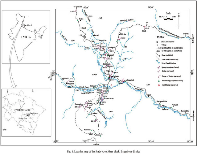 Apart from the springs and seepages, India Mark-II hand pumps have recently been installed in the area by Uttarakhand Jal Sansthan. These hand pumps are installed along all-weather motorable roads and are being extensively used for drinking and domestic work. They have replaced the traditional source of water supply to a great extent.
The discharge of springs and seepages in the study area varies from 0.06 to 4.8 lpm. Considering the local hydrogeological condition and spatial distribution, nine springs/seepages are selected for analysis of discharge and water temperature (2004-05) and the data are compared with the studies undertaken earlier (1978-79). The relevant observations are summarized in Table 1.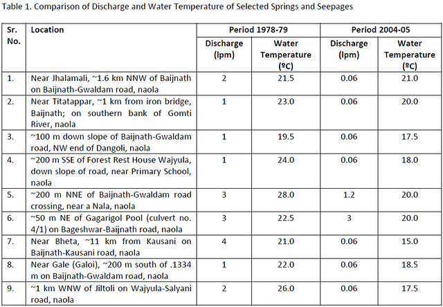 The spring discharge data given in Table 1 shows the spring discharge are reduced considerably over the years, except for one naola at Gagarigol where the variation is nil. A comparison of discharge of a naola at Jhalamali reveals that the discharge has been reduced from 2 lpm (Pre- monsoon, 1978) to 0.06 lpm (Pre-monsoon, 2004),thus indicating the reduction in discharge to 97%. The maximum reduction in the spring discharge (3.94 lpm) is observed at Bheta, which is a reduction of 98.5% of the original value. The springs and naolas in the area, based on the classification of discharge, are classified of 7th and 8th order (Meinzer, 1923).
The spring water temperature reveals that all the springs and naolas are of cold water. The absence of hot water/thermal springs in the area indicates that igneous intrusive (granite plutons) do not affect the localised aquifers in the area. However, a comparison of water temperature data for the periods 1978-79 and 2004-05 reveals that there is a general reduction in water temperature over the last twenty six years. The minimumreduction of 0.5ºC is recorded near Jhalamali whereas the maximum reduction of 8.5ºC is observed near Jiltoli. However, when the fall in water temperature is analysed in percentage, the reduction is only 32.69%. The reduction is also considerable (8ºC) in a naola near Baijnath-Gwaldam road crossing. However, again in percentage terms, the reduction is only 28.57%. A reduction of 6ºC is observed near Forest Rest House, Wajyula and near Bheta. However, the reductions are not significant in in terms of percentage; the reduction near Wajyula is only 25% and near Bheta, it is 28.57%.
The pipe line drinking water supply in the area is provided by Uttarakhand Pey Jal Nigam through domestic connections and Universal Stand Posts. As far as India Mark-II hand pumps is concerned, 12 such hand pumps were installed in Garur block and two were under installation (November 2004). Besides the India Mark-II hand pumps, some shallow hand pumps were also installed by local authorities and non government organisations. One such hand pump, in front of Block Development Office Garaser, was installed by a local drilling unit with the funding of local Gram Panchayat. The hand pump was installed by digging a shaft manually up to a depth of 11.28 m and constructing a storage tank (1.22m x 1.22 m x 0.61 m) at the bottom of the shaft and subsequently lowering the assembly. The water level was reported to be 4.27 m bgl, which may not reflect the actual water level in the areaas the hand pump may be tapping a shallow, perched aquifer. Some shallow hand pumps are also constructed by some of the Non Government Organisations in the study area. However, such hand pumps may not be able to give a sustainable discharge due to reasons mentioned above.
The discharge of the India Mark-II hand pumps ranges from 15 to 25 lpm (2003-04). A primary analysis of the discharge data reveals that 50% of the hand pumps have shown the highest discharge of 25 lpm, 33.33% have shown intermediate value of 20 lpm and the rest 16.67% have recorded the least discharge of 15 lpm. The depth to water, in the India Mark-II hand pumps, varies from 45.10 to >100 m bgl (2003-04). The static water level atBaijnath was 112.78 m bgl (May 2004) and at Laubanj, 99.06 m bgl (November 2004). The drilled depth of India Mark-II hand pumps varies from 69.00 to 121.95 m bgl. DTH method with ODEX attachment is suitable for this terrain. Auto flow or artesian condition is observed in a hand pump at Pingalkot, about 3.2 km NNE of Kausani on Baijnath-Kausani road.
HYDROCHEMISTRY
A total of thirty representative water samples were collected from different sources like springs, naolas and hand pumps during Pre-monsoon 2004. Another thirty three water samples were collected from these sources in Postmonsoon 2004. Out of these, the samples collected during Pre-monsoon are analysed for E.C., pH, bicarbonate(HCO3), chloride (Cl), total hardness (as CaCO3), nitrate (NO3), fluoride (F), calcium (Ca) and magnesium (Mg). Thesamples collected during Post-monsoon are analysed for sodium (Na) and potassium (K) also.
An effort is made to assess the suitability of water for irrigational use. Suitability of water for irrigation purposes is generally assessed using geochemical parameters like Sodium Adsorption Ratio (SAR), Soluble Sodium Percentage (SSP), Residual Sodium Carbonate (RSC), Kelly’s Ratio (KR) and Puri Salt Index (PSI). Sodium Adsorption Ratio,Soluble Sodium Percentage and Kelly’s Ratio are calculated for ten representative samples collected from springs and hand pumps in the area and are given along with pH, Electrical Conductivity (E.C.) and Total Dissolved Solids (TDS) in Table 2.
A study of Table 2 reveals that groundwater in the study area is mildly alkaline having pH from 7.8 to 8.0. The values indicate suitability of groundwater for irrigational purpose. Electrical Conductivity (E.C.) of groundwater in the study area are generally low and ranges from 142 to 640 μS/cm at 25°C. As per the quality classification of water for irrigational use (IS: 2296, 1963), the E.C. values are expressed as salinity hazard. Based on the classification, it is found that 6 out of 10 samples fall under “excellent” category (E.C. <250 μS/cm at 25°C) whereas remaining 4 samples fall under “good” category (E.C. 250-750 μS/cm25°C). This indicates the suitability of groundwater for irrigational use. Sodium Adsorption Ratio (SAR) in the study area varies from 0.21 to 0.85. The SAR values of all the samples, expressed as alkali hazard in the quality classification (IS: 2296, 1963), again indicates that groundwater of naolas and hand pumps is of “excellent” category (SAR up to 10). However, it is found that SAR values of water samples collected from hand pumps lies between 0.28 and 1.02, which is generally higher than corresponding SAR values in naolas. The values of salinity hazard (C) and sodium (alkali) hazard (S) clearly indicate 70% of water samples fall under C1S1 class as per the salinity classification adopted by the United States Department of Agriculture (Richards, 1954). Only three water samples (30% of total) collected from Garur market, TRC Baijnath and near Iron Bridge, Baijnath fall under the C2S1 class. The SAR values calculated for all the water samples in the study area are also within the permissible limit (<3.0) as per the guidelines of Food and Agriculture Organisation of the United Nations (Ayers and Westcot, 1985).
Soluble Sodium Percentage (SSP) in the naolas ranges from 7.88% to 38.0%. Corresponding values obtained from water of hand pumps show a variation from 11.89% to 28.84%. The values indicate that groundwater is suitable for irrigational use.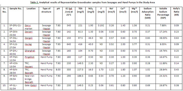 Computation of Kelly’s Ratio (KR) shows that values for water collected from seepages (naolas) range from 0.09 to 0.63. Corresponding KR values obtained for water samples collected from hand pumps vary from 0.14 to 0.43. Kelly’s Ratio of groundwater from different sources also supports the contention that the groundwater is suitablefor irrigation purpose.
Based on concentration of major ions and hydrochemical parameter like Total Hardness and Total Dissolved Solids (TDS), an attempt is made to assess the suitability of groundwater for drinking purpose. .The Total Hardness of groundwater in the area varies from 10 to 232 mg/l. Even the maximum value of Total Hardness is less than the desirable limit of 300 mg/l as per the Drinking Water Standard (BIS, IS: 10500, 1991). This reveals that groundwaterin the area is quite suitable for drinking purpose.
TDS of groundwater in the study area is calculated by applying the empirical relationship: TDS (mg/l) = 0.65 x E. C. (μS/cm) applicable for most natural waters having E.C. ranging from 100 to 5000 μS/cm at 25°C (Todd, 1980). The TDS values range from 92.3 to 416 mg/l. Even the maximum value of TDS in the area is below the desirable limit of 500 mg/l (BIS, IS: 10500, 1991), which indicates that groundwater is fresh and potable.Concentration of nitrate in groundwater of the study area is generally very less (<10 mg/l) except in two naolas where high nitrate is reported. The first one is near Kaulag (40 mg/l) and the second, near Dangoli (46 mg/l), the later value being marginally above the desirable limit of 45 mg/L (BIS, 1991). Concentration of fluoride in groundwater varies from 0.01 to 1.7 mg/l. The later value, obtained from a hand pump near Tourist Reception Centre Kausani, is marginally higher than the maximum permissible limit of fluoride in drinking water (BIS, 1991).
DISCUSSION
The springs and seepages in the area cater to drinking and domestic demands. However, due to the low discharge, many of them are being tapped along road sides in tanks (locally called Hauj). The Hauj based water supply is primarily maintained by Minor Irrigation Department along with some specific project based schemes under the aegis of District Project Management Unit under the “Swajal Pariyojana”. Artificial outlets in the form of PVC pipes, wood etc. are constructed in many Hauj that results in channelised flow of water for public use.
It is observed that groundwater in the area is generally colourless and odourless. However, water of some naolas is quite unsuitable for consumption as both solid and liquid waste is being disposed near them by humans. Such type of unhygienic practices need to be stopped immediately by creating awareness among the villagers about the availability vis-à-vis scarcity of safe drinking water in the mountainous tract. Also some hand pumps yield slightlyto highly turbid, yellowish brown to brown water in places like Wajyula, Gale (Galoi) and Garur Market. The yellowish brown colour is due to high iron content, which is also confirmed by the typical bittersweet taste of water. The local populace, consuming the water over long periods, runs the risk of chronic gastrointestinal disorder.
To overcome the problem of excess iron in groundwater, hand pump attachable Iron Removal Plants need to be installed in the area. The plant is based on an average discharge of 1 m3/hr (or about 16.67 lpm) of India Mark-II or equivalent hand pump. The hydraulic loading of the plant is adequate to serve a population of 250 at the rate of 100 lpcd. The plant comprises three chambers. Water from the outlet of the hand pump is sprayed over anoxidation chamber. The aerated water flows over baffle plate to a flocculation chamber and finally enters the sedimentation chamber. Subsequently, the filtered water from the sedimentation chamber is drawn through a tap after chlorination. The ferric precipitate settles as sludge and requires periodic scouring depending upon the quality of raw water and the quantity drawn through the hand pump. In this plant, no chemical is used exceptsolution of chlorine for disinfection. The capital cost of this iron removal plant is about Rs. 15,000. Except for cleaning twice in a month, the operation and maintenance cost of this plant are low. Hence they are quite suitable in locations having problem of high iron in groundwater.
During the survey, it is observed that villagers are generally aware of the problem of high iron and they have devised remedial measures at community and Gram Panchayat levels. For instance, residents of Garur, in association with the local Udyog Byapar Sangh, have constructed a large storage tank (similar to Hauj) and are tapping water from a spring located in higher reaches. By adapting this method, they have avoided drinking thewater with high iron content, which is coming from the nearby hand pump. The local populace, however, are using the water of the hand pump exclusively for domestic work.
Coming to the contamination aspect of groundwater in the study area, only nitrate and fluoride concentrations higher than the maximum permissible limit (as per BIS guidelines on drinking water) are recorded in isolated pockets in the area. The high nitrate concentration may be attributed to anthropogenic sources of contamination and hence need to be monitored more closely in future through detailed hydrochemical studies. Keeping in mindthe maximum permissible limit of 1.5 mg/l for fluoride (BIS, 1991), it may be prudent to carry out extensive hydrochemical surveys in and around Baijnath to avoid any possible health hazard due to fluoride contamination. However, the sporadically high fluoride concentration in the area may be attributed to geogenic factor like leaching of fluorine from the source (e.g. granites and/or other fluorite and apatite bearing country rocks) to the aquifer system.
The natural groundwater recharge in the hilly tracts of the area is very low due to extremely high surface runoff. Construction of artificial recharge structures like check dams, gully plugs, contour bunds and/or contour trenches can facilitate greatly in increasing the groundwater recharge in the hilly tracts of the area. Gully plugs and contourbunds are suitable for implementing artificial recharge schemes in low order small streams whereas check dams may be constructed in higher order streams. The artificial recharge structures, when constructed after carrying out site-specific hydrogeological surveys in a scientific manner, can aid in recharging the shallow aquifers in the area. They are also cost effective and have multifarious benefits like arresting surface run off, increasing soil moisture, helping in preventing soil erosion and increasing the discharge of nearby springs and seepages (naolas). Contour trenches may be constructed along hilly tracts with high land slope depending upon the local hydrologeological conditions. These trenches would cover the entire slopes uniformly whereas nala bunds constructed in a series would cover the entire stretch of drainage in the area.
CONCLUSIONS
Hydrogeology of Garur Valley is complex due to the structural and geotectonic characteristics of Lesser Himalayan Zone. The dominant rock types are high-grade metamorphic and metasedimentary rocks and terrace and channel alluvium in sections along the course of Gomti River. A study of twenty four cold-water springs and seepages(naolas) inventoried in the study area reveals that the discharge has been reduced considerably from the period 1978-79 to the period 2004-05. Many naolas recorded negligible discharge, both during the pre-monsoon and post-monsoon measurements. When compared with the measurements taken during earlier studies, a reduction in water temperature is observed in all the naolas in the area. However, the reduction, though considerable in magnitude, are usually low (<35%) when seen in percentage terms. Available discharge data of India Mark-II hand pumps indicates that majority of them (50%) have a discharge of 25 lpm. The depth to water in the hand pumps ranges from 45.10 to 112.78 m bgl whereas the drilled depth varies from 69.00 to 121.95 m bgl.
Except for high iron content in some hand pumps, the quality of groundwater in the area is good and suitable for human consumption. Study of geochemical parameters like Sodium Adsorption Ratio, Soluble Sodium Percentage and Kelly’s Ratio indicates that groundwater of representative naolas and hand pumps are excellent for irrigational use. Range of values of Electrical Conductivity and Total Dissolved Solids also indicate the suitability ofgroundwater for irrigation. Total Hardness and Total Dissolved Solids are well below the desirable limit as per the BIS guidelines for drinking water. The problem of excess iron in groundwater may be tackled by installing Iron Removal Plants with India Mark-II hand pumps. The plant is cost-effective and provides iron-free water if maintained regularly to retain its effectiveness. Nitrate concentration in the area is marginally higher than thedesirable limit (45 mg/l) and fluoride concentration is marginally higher than the maximum permissible limit (1.5 mg/l) in locations like Kaulag, Dangoli and Kausani. However, the high nitrate is attributed to unhygienic practices by humans around the naolas whereas high fluoride may be due to leaching of fluorine from the source to the aquifer system.
Acknowledgement: The author is thankful to the colleagues at Central Ground Water Board, Uttaranchal Region, Dehradun for fruitful discussions and constructive criticisms. The encouragement provided by the Regional Director, CGWB, UR is thankfully acknowledged. He also wishes to thank his family for the constant encouragement and support during the preparation of this paper.
REFERENCES
- Ayers, R. S. and Westcot, D. W., 1985. Water Quality for Agriculture, FAO Irrigation and Drainage Paper, 29 Rev. 1, Food and Agriculture Organization of the United Nations, Rome
- Bureau of Indian Standards (BIS), 1993. Government of India, Guidelines for Drinking Water, BIS, IS 10500:1991
- Heim, A. and Gansser, A., 1939. Central Himalaya, Geological Observation of the Swiss Expedition in 1936, Mem. Soc. Helv. Sci. Nat., 73, pp. 1-245
- Kelley, W. P., 1963. Use of saline irrigation water, Soil Science, 67, pp. 355-391
- Meinzer, O. E., 1923. Outline of ground-water hydrology with definitions, USGS Water Supply Paper 494, 71 p.
- Pande, I. C., 1956. Migmatites of Ramgarh, District Nainital, Jour. Sci. Research, Banaras Hindu University, No. 7, pp. 88-105
- Pande, I. C. and Verma, P. K., 1970. A Study of Migmatites Occurring Around Dangoli, Almora District, Uttar Pradesh, West Commemoration Volume, pp. 554-558
- Raghunath, H. M., 1987. Groundwater, 2nd Ed., New Age International Pvt. Ltd., India, pp. 344-369
- Richards, L. A., 1954. Diagnosis and improvement of saline and alkali soils, Agricultural Hand Book 60, United States Department of Agriculture, Washington, D. C., 160 p.
- Todd, D. K., 1980. Groundwater Hydrology, 2nd Ed., John Wiley & Sons (SEA) Pte Ltd, Singapore, 535 p.
- Zaidi, N., 1996. Hydrogeology and Groundwater Potential of Almora District, Uttar Pradesh, unpublished report of Central Groundwater Board, Northern Region, Lucknow, 105 p.
D. Bagchi
Central Ground Water Board, Uttaranchal Region, Dehradun


