


ABSTRACT
Najafgarh Drain (NGD) is the largest surface drains joining the Yamuna river in National Capital Territory. Its catchment area is around 374 sq.km. Because of severe constraints in the sewerage system in its drainage basin, NGD carries a very large quantity of urban waste water. In addition, it receives treated effluent from various STPs and freshwater from Western Yamuna Canal. NGD is one of the major source of pollution. NGD is the perennial drain and high level of flow in NGD makes this channel as a typical polluted river. In view of the magnitude of the inorganic and organic load carried by NGD and the path traversed by it through a major part of the city, it gains tremendous significance in the overall strategy for control of pollution in river Yamuna. This study aims to evaluate probable groundwater vulnerability due to emerging pollutants in Najafgarh drain, South West Delhi using solute transport modelling. Groundwater flow modelling shows that NGD is hydraulically connected with groundwater. In South West District NGD is recharging water to groundwaterand due to this groundwater is shallow along the NGD.
Keyword: Najafgarh Drain, urban waste water, groundwater vulnerability, emerging pollutan
INTRODUCTION
Najafgarh Drain (NGD) is the largest among all the surface drains joining the river in NCT. Its sewered catchment area is around 374 sq.km. Because of severe constraints in the sewerage system in its drainage basin, NGD carries a very large quantity of urban waste water. The combined discharge is over 2000 MLD, while the BOD load varies between 80 t/d to 195 t/d and; this alone represents 50% of hydraulic load and over 25% of organic load from NCT Delhi in to the river Yamuna. The urban waste water gets polluted in many ways.Runoff from streets carries oil, rubber, heavy metals, and other contaminants from automobiles. Untreated or poorly treated sewage can be low in dissolved oxygen and high in pollutants such as fecal coliform bacteria, nitrates, phosphorus, chemicals, and other bacteria. Treated sewage can still be high in nitrates. Groundwater and surface water can be contaminated from many sources such as domestic waste, garbage dumps, toxicwaste and chemical storage and use areas, leaking fuel storage tanks, and intentional dumping of hazardous substances. The presence of a wide variety of pharmaceutical and personal care products in water and wastewater has been frequently reported after the early findings of Ternes (1998) and Daughton and Ternes (1999). These compounds are a source of concern because they are used and released in large quantities and their physical and chemical properties contribute to their widespread distribution into the environment. Theconsequences are particularly worrying in aquatic organisms as they are subjected to multigenerational exposure (Halling-Sörensen et al., 1998). The presence of micropollutants also endangers the reuse of treated wastewater, a generally proposed solution to achieve a sustainable water cycle management. Pharmaceutical and personal care products represent a rising part of the trace organic micropollutants found in urban and domestic wastewaters that reach sewage treatment plants (STP), either metabolised or not. Many of thesesubstances escape to conventional activated sludge wastewater treatments allowing them to reach surface water streams and distribute in the environment (Tauxe-Wuersch et al., 2005).
So far no study has been carried out to evaluate the extent of vulnerability of groundwater pollution in NGD. A maiden attempt has been made to delineate vulnerability of groundwater along Najafgarh Drain using numerical simulation technique to comprehend the present and future migration of emerging pollutants. Due to paucity of specific data for the NGD, average pollutants carried out by any urban waste water drain reported in published literature is considered here.
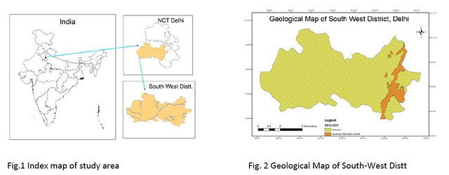
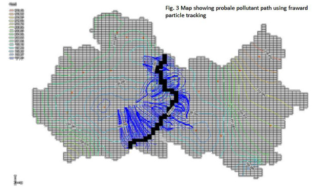
The study area is situated in south west part of Delhi (Figure 1) and it lies between 28° 30’-28°40’ N lat. and 76°50’ -77° 12’ E long. It is spread over an area of about 420 km2 and is characterized by undulating topography with hills located in the southern parts, sloping towards north and northwest. The highest elevation (altitude) in the south east part of the district is of the order of 290 m amsl, whereas in the plains it ranges from 190 m amsl in the western part of the area. NGD flows south to north. The average annual rainfall is of the order of 750 mm for the period 1971–2001. Geologically, the area is occupied with Alwar quartzites in the east and fluvio-aeolian deposits in the rest of the district(Fig.2). The borehole data of Central ground Water Board (CGWB) shows alternation of fluvial bands with Aeolian bands in sporadic manner. The sediments are mostly silt with medium to find sand, clay and Kankar. The depth to bedrock data indicates towards steep subsurface escarpment on western side of the Delhi ridge (Alwar Quartzites) exposed in the district (Shashank, etal, 2006). The general trend of groundwater flow direction of shallow aquifer is in the north and northeast directions (Figure 3).
METHODOLOGY
Ground water flow model is the pre-requisite for solute transport modelling. A steady state groundwater flow model is developed . In order to set up ground water flow model in the MODFLOW set of codes, the area of interest needs to be discritized into in the e form of grids. This grid has to be block-centred, i.e. the groundwater heads will be computed at the centre of each grid block. The areal extent of the basin in about 420 km2, a grid size of 500x500 m was decided (Figure 4). The cell size was further refined along NGD to meetthe peclet and courant criterion. The actual values of the ground surface elevation and bottom elevation of the bedrock were entered in the model. In the present case, the boundary conditions had been determined based on the hydraulic condition and flow net analysis of water table contour map. No-flow boundary has been set in the eastern and north-eastern south-western part of the study area because Alwar Quartzites has beencharacterized as practically impermeable in the conceptual model and flow lines are parallel to boundary.
 Specified flow (Neumann conditions) were assigned at remaining places . Inflow and out flow were calculated based on Darcy flux. Initially hydraulic conductivity and recharge were assigned based field data collected by CGWB in previous studies. Water balance technique was used to make initial estimates to Recharge rates. Based on remote sensing study it was observed that study area comprises two distinct landuse/landcover pattern that is urban area and rural area. Recharge rates for urban area was assigned as 10% of the meanannual rainfall and 30% for agricultural activity dominated rural area. These input parameters were further refined using inverse modelling .The data for groundwater draft from irrigation, industries and domestic was taken from published literature (CGWB, 2004). Model calibration was done by modifying hydraulic conductivity and recharge rates. Final figures were arrived after inverse modelling.
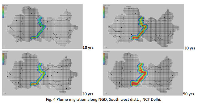
Solute Transport Modeling
MT3DMS software developed by USGS (Zheng and Wang,1999) was used to simulate changes in concentrations of miscible contaminants in groundwater considering advection, dispersion, diffusion, and some basic chemical reactions, with various types of boundary conditions and external sources or sinks. The concentration of pollutant(TDS) in the NGD was assumed to be more than 20000 mg/l. It was assumed that 30% of the sewerage flow seeps into the groundwater system. After natural attenuation, retardation and sorption it was assumed that on a conservative basis the pollutants reaching the water table has a soluteconcentration, which is 30% of that present at the surface. An effective porosity of 0.25 for fluvioeolian deposits and 0.1 for Alwar quartzites were uniformly assumed for the entire area. Longitudinal dispersitivity was taken as 10m to generate different scenarios for migration emerging pollutants. Since migration of pollutants depends on various factors like octanal water partition coefficient, organic carbon partition coefficient, Henry law coefficient, hydrolysis and biotransformation. The transport model was run until the contaminant plume has reached steady state conditions. Assuming the source of the contaminant flux remainsnear constant.
RESULTS AND DISCUSSION
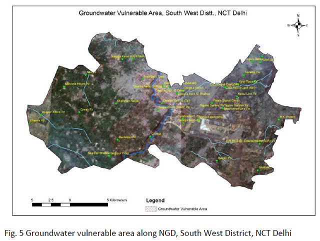
The model calculated TDS concentration for 20 years shows that the pollutant could migrate only to about 1000 m all around from the NGD. During next 50 years the pollutant migrated to about 2500 m around the NGD. After delineating groundwater vulnerable area along NGD it is estimated that about 73 sq. km. area is vulnerable to groundwater pollution (Fig. 5). To arrest this contaminant migration in situ remediation technology like permeable reactive barrier(PRB) option is need to be explored. A PRB is a passive in situ treatment zone of reactive material that degrades or immobilizes contaminants as ground water flows throughit. PRBs are installed as permanent, semi-permanent, or replaceable units across the flow path of a contaminant plume. Natural gradients transport contaminants through strategically placed treatment media. The media degrade, sorb, precipitate, or remove chlorinated solvents, metals, radionuclides, and other pollutants. These barriers may contain reactants for degrading volatile organics, chelators for immobilizing metals, nutrients and oxygen to enhance bioremediation, or other agents. It is to be mentioned that this model shows only potential vulnerable area and before making final conclusion detail water quality data isneed to be analysed.
CONCLUSIONS
It is recommended to periodically monitoring of the water level and water quality( including inorganic and organic compound) along NGD is required often to ascertain changing groundwater scenario. Well head protection measures need be taken up for all abstraction structures to avoid entering of pollutants. Other than rainfall NGD is the only source of recharge. In this regard it is to mention that high level of contamination in NGD may have adverse impact on groundwater quality. Therefore to control further advancement ofcontaminate migration installation of PRBs is recommended.
ACKNOWLEDGMENT
Authors are thankful to Chairman, CGWB for inspiration and encouragement and also grateful to Member(SAM), for his guidance. Thanks are also due to Dr S Shekhar, S K Swaroop, Dr A Mukherjee and Dr V Sharma for support and motivation.
REFERENCES
- Daughton, C.G.; Ternes, T.A., 1999 'Pharmaceuticals and personal care products in the environment: Agents of subtle change?' Environ. Health Perspect., 107(suppl 6), 907-938
- Halling-Sørensen, B., Nors Nielsen, S., Lanzky, P.F., Ingerslev, F., Holten Lu¨tzhøft, H.C., Jørgensen, S.E., 1998. Occurrence, fate and effects of pharmaceutical substances in the environment – a review. Chemosphere 36, 357–393
- Tauxe-Wuersch A., De Alencastro L.F., Grandjean D., Taradellas J., 2005, Occurance of several acidic drugs in sewage treatment plants in Switzerland and risk assessment, Water Research 39, 1761- 1772
- Ternes, T.A.,1998 'Occurrence of drugs in German sewage treatment plants and rivers,' Water Res., 32(11), 3245-3260
- Shashank Shekhar , Mohiddin, S. K. and Singh, P. N., 2006 . Variation in concentration of fluoride in ground water of SW dist. , Delhi- a case study, Second International Conference , Groundwater for sustainable development, problems, perspective and challenges, IGC-2006, Jawahar Lal Nehru University, New Delhi.
Rajesh Chandra, S. K. Sinha, A K Sinha
Central Ground Water Board, Faridabad
Deptt of Geology, University of Rajasthan
Posted by


