


1.0 INTRODUCTION AND BACKGROUND
Water Resources of a country constitute one of its vital assets. With about four percent (4%) of world's water resources available in the country, the presumption that these are inexhaustible is proving incorrect. With the increase in population, urbanization and industrialization, the demand of water for various uses is increasing continuously, thereby reducing per capita water availability. India is a developing country with a vast territory, complex and diverse topography, varied climate and a large population. The precipitation and runoff in the country is not only unevenly distributed, but also uneven with regard to temporal distribution of water during the year. India being a predominantly agriculture dependent country, its economic development is linked to agriculture. The major limiting factor for agriculture is water. A growing population and consequent need for increase in food production thereby requiring increasing area of agricultural fields and irrigation are resulting in tremendous pressure over water. Due to overexploitation of water resources, it has become scarce in many parts of our country. Needless to say, under such a scenario “Water Conservation and Management” is of great importance to the economic, social and cultural development in India.
2.0 TRADITIONAL METHODS OF WATER CONSERVATION ANDMANAGEMENT
Water conservation is a key element of any strategy that aims to alleviate the water scarcity crisis in India. With rainfall patterns changing almost every year, the Indian government has started looking at means to revive the traditional systems of water harvesting in the country. Given that these methods are simple and eco-friendly for the most part, they are not just highly effective for the people who rely on them but they are also good for the environment.
History tells us that both floods and droughts were regular occurrence in ancient India. Perhaps this is why every region in the country has its own traditional water conservation and management techniques that reflect the geographical peculiarities and cultural uniqueness of the regions. The basic concept underlying all these techniques is that rain should be harvested whenever and wherever it falls.
Archaeological evidence shows that the practice of water conservation and management is deep rooted in the science of ancient India. Excavations show that the cities of the Indus Valley Civilization had excellent systems of water conservation, harvesting and drainage system. The settlement of Dholavira, laid out on a slope between two storm water channels, is a great example of Water Engineering. Chanakya’s Arthashashtra mentions irrigation using water harvesting systems. Sringaverapura, near Allahabad, had a sophisticated water harvesting system that used the natural slope of the land to store the floodwaters of the river Ganga. Chola King Karikala built the Grand Anicut or Kallanai across the river Cauvery to divert water for irrigation (it is still functional) while King Bhoja of Bhopal built the largest artificial lake in India.
Drawing upon centuries of experience, Indians continued to build structures to catch, hold and store monsoon rainwater for the dry seasons to come. These traditional techniques, though less popular today, are still in use and efficient. Drawing upon centuries of experience, Indians continued to build structures to catch, hold and store monsoon rainwater for the dry seasons to come. Water has been conserved and managed in India since antiquity, with our ancestors perfecting the art of water management. Many water conservation structures and water conveyance systems specific to the ecoregions and culture has been developed as shown in figure.
The traditional Water Conservation and Management practiced based on the Ecological Regions of India are tabulated below:
Sr. No. | Ecological Region | Traditional Water Management System |
1. | Trans - Himalayan Region | Zing |
2. | Western Himalaya | Kul, Naula, Kuhl, Khatri |
3. | Eastern Himalaya | Apatani |
4. | North Eastern Hill Ranges | Zabo |
5. | Brahmaputra Valley | Dongs / Dungs/ Jampois |
6. | Indo-Gangetic Plains | Ahars – Pynes, Bengal’s Inundation Channels, Dighis, Baolis |
7. | The Thar Desert | Kunds, Kuis/beris, Baoris / Ber/ Jhalaras, Nadi, Tobas, Tankas, Khandins, Vav/Bavadi, Virdas, Paar |
8. | Central Highlands | Talab, Bandhis, Saza Kuva, Johads, Naada/Bandh, Pat, Rapat, Chandela Tank, Bundela Tank |
9. | Eastern Highlands | Katas / Mundas / Bandhas |
10. | Deccan Plateau | Cheruvu, Kohli Tanks, Bhandaras, Phad, Kere, The Ramtek Model |
11. | Western Ghats | Surangam |
12. | West Coastal Plains | Virdas |
13. | Eastern Ghats | Korambu |
14. | Eastern Coastal Plains | Eri / Ooranis |
15. | The Islands | Jack Wells |
These traditional techniques, though less popular today, are still in use and efficient. Brief details of these techniques of water conservation and management systems prevalent in India who have practiced them for decades before the debate on climate change even existed based on ecological Regions of India are given below:
1. Jhalara
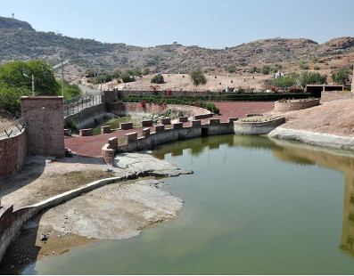
 Jhalaras are typically rectangular-shaped step wells that have tiered steps on three or four sides. These step wells collect the subterranean seepage of an upstream reservoir or a lake. Jhalaras were built to ensure easy and regular supply of water for religious rites, royal ceremonies and community use. The city of Jodhpur has eight jhalaras, the oldest being the Mahamandir Jhalara that dates back to 1660 AD.
2. Talab /Bandhi
Talabs are reservoirs that store water for household consumption and drinking purposes. They may be natural, such as the pokhariyan ponds at Tikamgarh in the Bundelkhand region or manmade, such as the lakes of Udaipur. A reservoir with an area less than five bighas is called a talai, a medium sized lake is called a bandhi and bigger lakes are called sagar or samand.
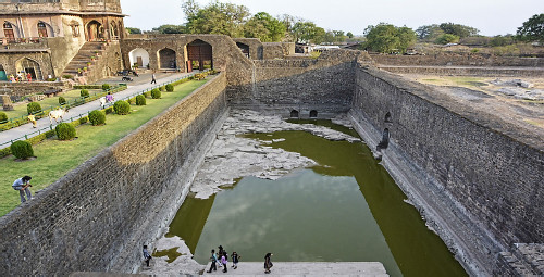
3. Bawari
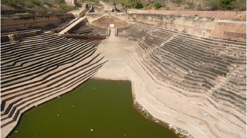 Bawaris are unique step wells that were once a part of the ancient networks of water storage in the cities of Rajasthan. The little rain that the region received would be diverted to manmade tanks through canals built on the hilly outskirts of cities. The water would then percolate into the ground, raising the water table and recharging a deep and intricate network of aquifers. To minimize water loss through evaporation, a series of layered steps were built around the reservoirs to narrow and deepen the wells.
 4. Taanka
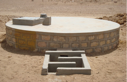 Taanka is a traditional rainwater harvesting technique indigenous to the Thar Desert region of Rajasthan. A Taanka is a cylindrical paved underground pit into which rainwater from rooftops, courtyards or artificially prepared catchments flows. Once completely filled, the water stored in a taanka can last throughout the dry season and is sufficient for a family of 5-6 members. An important element of water security in these arid regions, taankas can save families from the everyday drudgery of fetching water from distant sources.
5. Ahar Pynes
 Ahar Pynes are traditional floodwater harvesting systems indigenous to South Bihar. Ahars are reservoirs with embankments on three sides that are built at the end of diversion channels like pynes. Pynes are artificial rivulets led off from rivers to collect water in the ahars for irrigation in the dry months. Paddy cultivation in this relatively low rainfall area depends mostly on ahar pynes.
6. Johads
 Johads, one of the oldest systems used to conserve and recharge ground water, are small earthen check dams that capture and store rainwater. Constructed in an area with naturally high elevation on three sides, a storage pit is made by excavating the area, and excavated soil is used to create a wall on the fourth side. Sometimes, several johads are interconnected through deep channels, with a single outlet opening into a river or stream nearby. This prevents structural damage to the water pits that are also called madakas in Karnataka and pemghara in Odisha.
7. Panam Keni
 The Kuruma tribe (a native tribe of Wayanad) uses a special type of well, called the panam keni, to store water. Wooden cylinders are made by soaking the stems of toddy palms in water for a long time so that the core rots away until only the hard outer layer remains. These cylinders, four feet in diameter as well as depth, are then immersed in groundwater springs located in fields and forests. This is the secret behind how these wells have abundant water even in the hottest summer months.
8. Khadin
 Khadins are ingenious constructions designed to harvest surface runoff water for agriculture. The main feature of a khadin, also called dhora, is a long earthen embankment that is built across the hill slopes of gravelly uplands. Sluices and spillways allow the excess water to drain off and the watersaturated land is then used for crop production. First designed by the Paliwal Brahmins of Jaisalmer in the 15th century, this system is very similar to the irrigation methods of the people of ancient Ur (present Iraq).
9. Kund
 A kund is saucer-shaped catchment areas that gently slope towards the central circular underground well. Its main purpose is to harvest rainwater for drinking. Kunds dot the sandier tracts of western Rajasthan and Gujarat. Traditionally, these well-pits were covered in disinfectant lime and ash, though many modern kunds have been constructed simply with cement. Raja Sur Singh is said to have built the earliest known kunds in the village of Vadi Ka Melan in the year 1607 AD.
10. Baoli
 Built by the nobility for civic, strategic or philanthropic reasons, baolis were secular structures from which everyone could draw water. These beautiful step wells typically have beautiful arches, carved motifs and sometimes, rooms on their sides. The locations of baolis often suggest the way in which they were used. Baolis within villages were mainly used for utilitarian purposes and social gatherings. Baolis on trade routes were often frequented as resting places. Step wells used exclusively for agriculture had drainage systems that channelled water into the fields.
11. Nadi
 Found near Jodhpur in Rajasthan, nadis are village ponds that store rainwater collected from adjoining natural catchment areas. The location of a nadi has a strong bearing on its storage capacity and hence the site of a nadi is chosen after careful deliberation of its catchment and runoff characteristics. Since nadis received their water supply from erratic, torrential rainfall, large amounts of sandy sediments were regularly deposited in them, resulting in quick siltation. A local voluntary organization, the Mewar Krishak Vikas Samiti (MKVS) has been adding systems like spillways and silt traps to old nadis and promoting afforestation of their drainage basin to prevent siltation.
12. Bhandara Phad
 Phad, a community-managed irrigation system, probably came into existence a few centuries ago. The system starts with a bhandhara (check dam) built across a river, from which kalvas (canals) branch out to carry water into the fields in the phad (agricultural block). Sandams (escapes outlets) ensure that the excess water is removed from the canals by charis (distributaries) and sarangs (field channels). The Phad system is operated on three rivers in the Tapi basin – Panjhra, Mosam and Aram – in the Dhule and Nasik districts of Maharashtra.
13. Zing
 Zings, found in Ladakh, are small tanks that collect melting glacier water. A network of guiding channels brings water from the glacier to the tank. A trickle in the morning, the melting waters of the glacier turn into a flowing stream by the afternoon. The water, collected by evening, is used in the fields on the following day. A water official called a Chirpun is responsible for the equitable distribution of water in this dry region that relies on melting glacial water to meet its farming needs.
14. Kuhls
 Kuhls are surface water channels found in the mountainous regions of Himachal Pradesh. The channels carry glacial waters from rivers and streams into the fields. The Kangra Valley system has an estimated 715 major kuhls and 2,500 minor kuhls that irrigate more than 30,000 hectares in the valley. An important cultural tradition, the kuhls were built either through public donations or by royal rulers. A kohli would be designated as the master of the kuhl and he would be responsible for the maintenance of the kuhl.
15. Zabo
 The Zabo or Ruza (meaning ‘impounding run-off’) system of Nagaland combines water conservation with forestry, agriculture and animal care. Rainwater that falls on forested hilltops is collected by channels that deposit the run-off water in pond-like structures created on the terraced hillsides. The channels also pass through cattle yards, collecting the dung and urine of animals, before ultimately meandering into paddy fields at the foot of the hill. Ponds created in the paddy field are then used to rear fish and foster the growth of medicinal plants.
16. Bamboo Drip Irrigation
 Bamboo Drip irrigation System is an ingenious system of efficient water management that has been practiced for over two centuries in northeast India. The tribal farmers of the region have developed a system for irrigation in which water from perennial springs is diverted to the terrace fields using varying sizes and shapes of bamboo pipes. Best suited for crops requiring less water, the system ensures that small drops of water are delivered directly to the roots of the plants. This ancient system is used by the farmers of Khasi and Jaintia hills to drip-irrigate their black pepper cultivation.
17. Jackwells
 The Shompen tribe of the Great Nicobar Islands lives in a region of rugged topography that they make full use of to harvest water. In this system, the low-lying region of the island is covered with jackwells (pits encircled by bunds made from logs of hard wood). A full-length bamboo is cut longitudinally and placed on a gentle slope with the lower end leading the water into the jackwell. Often, these split bamboos are placed under trees to collect the runoff water from leaves. Big jackwells are interconnected with more bamboos so that the overflow from one jackwell leads to the other, ultimately leading to the biggest jackwell.
18. Ramtek Model
 The Ramtek model has been named after the water harvesting structures in the town of Ramtek in Maharashtra. An intricate network of groundwater and surface water bodies, this system was constructed and maintained mostly by the malguzars (landowners) of the region. In this system, tanks connected by underground and surface canals form a chain that extends from the foothills to the plains. Once tanks located in the hills are filled to capacity, the water flows down to fill successive tanks. This system conserves about 60 to 70 % of the total runoff in the region.
19. Pat System
 The Pat system, in which the peculiarities of the terrain are used to divert water from hill streams into irrigation channels, was developed in the Bhitada village in Jhabua district of Madhya Pradesh. Diversion bunds are made across a stream near the village by piling up stones and then lining them with teak leaves and mud to make them leak-proof. The Pat channel then passes through deep ditches and stone aqueducts that are skillfully cut info stone cliffs to create an irrigation system that the villagers use in turn.
20. Eri
 The Eri (tank) system of Tamil Nadu is one of the oldest water management systems in India. Still widely used in the State, eris act as flood-control systems, prevent soil erosion and wastage of runoff during periods of heavy rainfall, and also recharge the groundwater. Eris can either be a system eri, which is fed by channels that divert river water, or a non-system eri, that is fed solely by rain. The tanks are interconnected in order to enable access to the farthest village and to balance the water level in case of excess supply. The eri system enables the complete use of river water for irrigation and without them, paddy cultivation would have been impossible in Tamil Nadu. There are several other hyper local versions of the traditional method of tank irrigation in India. From keres in Central Karnataka and cheruvus in Andhra Pradesh to dongs in Assam, tanks are among the most common traditional irrigation systems in our country.
21. Apatani
 It is a multipurpose water management system, which integrates land, water and farming systems by protecting soil erosion, conserving water for irrigation and paddy-cum-fish culture. This is wet rice cultivation cum fish farming system practiced in elevated regions of about 1600 m and gentle sloping valleys, having an average annual rainfall about 1700 mm and also rich water resources like springs and streams. This system harvests both ground and surface water for irrigation. It is practiced by Apatani tribes of Ziro in the lower Subansiri district of Arunachal Pradesh.
In Apatani system, valleys are terraced into plots separated by 0.6 meters high earthen dams supported by bamboo frames. All plots have inlet and outlet on opposite sides. The inlet of low lying plot functions as an outlet of the high lying plot. Deeper channels connect the inlet point to outlet point. The terraced plot can be flooded or drained off with water by opening and blocking the inlets and outlets as and when required. The stream water is tapped by constructing a wall of 2-4 m high and 1 m thick near forested hill slopes. This is conveyed to agricultural fields through a channel network. There is necessity to introduce high yielding varieties of paddy and fish to augment the income of the farmers from this system. This system and structures are highly successful and has been continued for years in the area. This is an ideal example of indigenous technology developed by the rural farmers.
22. Cheo-ozihi
The river Mezii flows along the Angami village of Kwigema in Nagaland and the river water is tapped in seven different places in different elevations by means of channel diversion. The river water is brought down by a long channel from which many branches take off, and water is often diverted to the terraces through bamboo pipes. One of the channels is called Cheo-ozihi. Ozihi means water and Cheo was the person responsible for the laying of this 8- 10 km-long channel with its numerous branches. The channels are maintained and cleared each year by the local community. This channel irrigates a large number of terraces in Kwigema, and some terraces in the neighboring village.
23. Roof top water harvesting in Mizoram
 In Mizoram most of the hills are steep having slope more than 50 per cent and are separated by deep river gorges. Despite of heavy monsoon rain, the people face acute water problems every year in the dry season. The geological formation does not permit water retention; runoff is quick and springs and small streams dry up when there is no rain. Roof top harvesting structures for drinking purpose have been developed locally and now spread in the entire Mizoram. It has proved to be quite successful. Most houses are built with sloping roofs with galvanized iron sheets to be quite successful. Most houses are built with sloping roofs with galvanized iron sheets which are conducive to rain water harvesting. A common method of storing rain water is to place horizontal rain gutters along the sides of sloping roof, which is normally made of corrugated iron sheets. Rain water pours into a pipe connected to the tank which is mostly made from GCI sheets or galvanized plain sheets. But many people have started using reinforced cement concrete tanks, located in the court yard or under the house. Now the government of Mizoram has a policy to replace thatch roof with GCI sheet roofs to improve village houses and also to provide loan for promoting roof top water harvesting.
It can be noted from above that these techniques had evolved historically as per site specific conditions (topography) and according to the peculiar climate and geology (soil) prevailing therein. The scale of the projects/schemes was not large and mostly located in a decentralized manner and community owned at times serving multiple purposes as well. These micro/small scale techniques were suited to subsistence economy, till the population pressure was controlled and there were limited uses of water (mostly drinking and household). A major reason for the breakdown of this traditional system is the pressure of centralization and agricultural intensification. At the same time, there were occurrences of floods and instances of droughts/famines in spite of such practices in vogue.
However, these ecologically safe traditional systems are viable and cost-effective alternatives to rejuvenate India’s depleted water resources. Productively combining these structures with modern rainwater-saving techniques, such as percolation tanks, injection wells and subsurface barriers, could be the answer to India’s perennial water woes.
Small projects, per-se cannot by themselves, adequately intercept the large quantum of rainfall available for exploitation in a sustained manner. Economy of scale, much lesser evaporation losses, the safety and flood absorption potential, are only available with large storage projects. However, small dams can be considered as worthy supplements but not substitutes for large dams. The storage behind large dams in any basin ensures that there is a cushion of reserve as well as in-built carry-over storage. In view of significant storage capacity, the large dams can have adequate flood cushion to moderate heavy floods. Further even without specifically earmarked flood storage, the flood moderation is being achieved in large dams by suitable regulation of outflows. Of course, before taking a decision of construction of large dams, all other alternatives like several smaller dams or cascade development schemes need to be considered in detail and compared with the large dam option.
Water is also a source of energy. The large dams and reservoirs can help generate considerable hydro-power which also helps in enhancing the economic viability of the project. In fact, most of the existing dams provide multiple benefits. Thus, for harnessing untapped water resources, apart from irrigation and drinking water supply, energy generation can also be provided, where feasible, thereby facilitating proper hydro-thermal mix for improving operational reliability. It has been seen that the existing dams have also significantly increased economic activity in the catchment areas, because of increased tempo of construction activities, commerce and tertiary development as well as promotion of tourism, fishing etc.


