


Abstract
One half of the world populations are dependent on ground water for their everyday domestic uses, and hygiene. In fact, ground water is the most extracted natural resource in the world. The constant trend of emergent populations and mounting economies, many aquifers today are being depleted while others are being contaminated. In spite of the world’s considerable dependence on ground water resource, secondary attention is being received as compared to surface water, especially among legislatures and policymakers. Today, while there are hundreds of treaties governing transboundary rivers and lakes, there is only one international agreement that directly addresses a transboundary aquifer. Given that many of the aquifers on which humanity so deeply relies cross international borders, there is a significant gap in the sound management, allocation, and protection of such resources. In order to prevent future disputes over transboundary aquifers and to maximize the beneficial use of this resource, international law must be clarified as it applies to transboundary ground water resources. Moreover, it must be defined with a firm basis in sound scientific understanding to ground water systems.
Transboundary aquifers are vital component of global water resource systems, though their recognition in international water policy and legislation is very limited. Study on transboundary aquifer systems is very important to the Hydrogeologist to encourage riparian countries and states to work cooperatively toward mutually beneficial and sustainable aquifer development. Ground water is usually part of a greater hydrologic system, sometimes with the surface or ground water of neighboring states. It is rare that a transboundary river is not linked to a domestic or transboundary aquifer.
The Brahmaputra basin provides a good model for transboundary water resources management and aquifer systems. North Eastern States comprises the states of Arunachal Pradesh, Assam, Manipur, Meghalaya, Mizoram, Nagaland, Tripura and Sikkim. Hill ranges occupy about 70% of the total geographical area. The region has three principal drainage system viz. Brahmaputra, Ganga and Barak. All the drainage system confluences at Bangladesh. Albeit, the region receives highest rainfall and experiences floods during monsoon, there is acute shortage of drinking water in many parts of hilly terrains such as Cherrapunji, in Meghalaya, which is the second wettest place in the world. Though blessed with 1/3rd of the water resource potential of the country, the agro-economic condition of the region is poor as only a negligible amount of ground water resource (about 13%) has been utilized so far.
INTRODUCTION AND BACKGROUND
Transboundary aquifers have long been recognized (e.g., Bittinger 1972; Hayton and Utton 1989), however, their significance and function in environmental and human development has received limited attention from policy makers, unlike transboundary river basins (Bourne 1992). Consequently, there are neither global policies nor appropriate legal instruments to govern this vital natural resource. In an effort to remove this gap, following its 1997 Congress in Nottingham, UK, the International Association of Hydrogeologists (IAH) established a Commission on Transboundary Aquifer Resources Management (TARM) to promote their study and joint international cooperation. The inventory of European transboundary aquifers (Arnold and Buza´s, 2005) provides many valuable lessons for other regions and developing countries, not least that nomenclature and hydrogeological mapping across international boundaries still requires better coordination. The paper by Eckstein and Eckstein (2005) provides basic topologies of transboundary aquifers so that international law can be better formulated. The paper by Jarvis et al. (2005) investigates the hydropolitical complexities in the management of transboundary aquifers.
IDENTIFICATION OF TRANSBOUNDARY AQUIFERS
The recognition of transboundary aquifers should lead to mutual international acceptance of an effective and equitable management of shared resources. In contrast to surface water, groundwater resource boundaries are often very poorly known and so many transboundary aquifers remain only partly recognized. Nevertheless, it is essential to view the entire aquifer system, including all aquifers that are hydraulically interconnected, directly by lateral or indirectly through vertical contact or through fractures and low permeability formations (aquitards). Spatial distribution of aquifer parameters is important in the understanding of transboundary problems. The following factors may affect the behavior and the development potential of aquifers, includes:
- Hydraulic parameters;
- Rainfall and recharge zones;
- Confined and unconfined areas;
- Natural discharge zones;
- Present and planned groundwater development zones;
- Water quality, potential risks of its deterioration; and
- Vulnerability to polluting agents.
In transboundary aquifers one or more of these factors may receive a different weighting on either side of a boundary. There are several examples of transboundary aquifers where recharge is received on one side while the natural discharges (and sometime better yields) are across the border. Such conditions are found in the border areas of Meghalaya, India and Bangladesh.
Groundwater hydraulics that may have international implications: Water abstraction from an aquifer transforms and re-organizes the groundwater flow in proportion to the piezometric adjustments induced. This has a number of practical consequences in the study of aquifer boundary conditions.
Modification of the Groundwater flow pattern: Groundwater flow passing an international boundary cannot be measured directly. It is estimated from parameters and calculated through mathematical models. Abstraction on one side of the border may alter the flow through the border.
Modification of the Piezometric Surface: Groundwater abstraction from wells results in modifications of piezometric heads in the form of a concentric cone of depression. Cones of depression may spread beyond international borders.
Deterioration of the water quality: Water quality deterioration may take place as a result of development. The impacts could be transmitted from unilateral actions in one of the countries sharing the transboundary resource. Vulnerability of aquifer is higher when groundwater moves through formations where large interconnected fractures or cavities are present and encourage rapid flow as in the case of the karstic aquifers (Margat, 1992).Human activities at the ground surface, e.g. landfill of waste, can result in aquifer pollution. The polluted groundwater from one side of an international boundary can travel to the other. Once polluted, aquifer cleanup is slow and expensive; the detection of its sub surface distribution can also be expensive. One of the differences between surface and groundwater resources is the time needed to detect pollution. In the aquifer systems impacts generated by the present generation may be detected by the future generations.
TRANSBOUNDARY AQUIFERS IN ASIA AND NORTH EAST INDIA
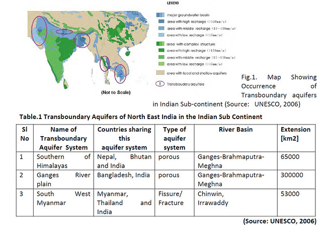
The disposition of transboundary aquifer in Asia is shown in fig 1 and the transboundary aquifers of north east India are given in table 1
Transboundary aquifers in Asia:- Transboundary aquifers, as part of groundwater resource systems, are important for Asian countries. The aquifers are involved within the relationship between countries, regions, as well as along the international rivers. There are several transboundary aquifers, involving two or more countries in Asia. Research on transboundary aquifers is significant for the management of shared groundwater resources of neighboring countries or regions. Transboundary aquifers in Asia have been briefly discussed. They are based on groundwater systems analysis. These aquifers are important for building a society where all civilizations can coexist harmoniously and accommodate each other. According to the groundwater resource data collected, the groundwater systems in central, east, and south Asia are analyzed. The information about the groundwater flows should be exchanged among the Asian countries, which share the same transboundary aquifer system. These are basic requirements for the joint management of water resources.
 Groundwater aquifers in North East India:- The Northeast is divided into isolated plains encompassed within hills, with a number of agro-climatic zones within them. It is characterized by heavy precipitation, extremely rich bio-diversity, fragile hills, high seismicity, and a drainage pattern marked by lateral valleys in the north and transverse valleys in the south, dissected by huge rivers and raging torrents. It was left with over 4500 km of external frontier with Bhutan, China, Myanmar and Bangladesh but no more than a slender 22 km connection with the Indian heartland through the tenuous Siliguri corridor, the Gateway to the Northeast. The Northeast spreads over a vast expanse of 255,000 sq. km with a relatively small population of fewer than 40 million today.
At the north-eastern extremity of Himalayas, a ittle beyond the peak Namcha Barwa, the geological formations turn sharply southwards and form the conspicuous arc forming the border of India and Burma (Myanmar), continuing into the Andaman and Nicobar islands and Indonesian Archipelago. The Burmese arc on the Indo-Burma border is an area about which very little is known, except for the meager information obtained from a few traverses. It is composed of the Patkai, Naga, Manipur, Lushai, Chin, Arakan and other ranges. The Median Tertiary belt of Burma lying to the east of these ranges corresponds to the Tertiary zone of Baluchistan, while the zone of the Shan Plateau, with its Pre-Cambrian, Paleozoic and Mesozoic rocks, is a foreign element beyond the original Tethyan zone, and belongs to South East Asia belonging to the Indo-China province.
The Brahmaputra originates in Tibet (5300m above MSL) and it enters India at Arunachal Pradesh after a distance of 1625 kms. It changes its direction towards the end of Tibet for North East India, then north and sweeping a miniature twist, and then drops down the Namcha Barwa massifs towards south and south west entering Indian Territory. The river travel 260 kms before debouching into Indian Territory, the Tsangpo, its name there, drops through height of 2200 metres.
The region shows an array of geological formations ranging in age from Precambrian to Quaternary. However, semi-consolidated sedimentary formations of Tertiary age developed along-with Precambrian rocks are the predominant formations of the region. The geological formations in North Eastern India are generally grouped under three main categories: i. Unconsolidated formations, ii. Semi-consolidated formations iii Consolidated formations
i. Unconsolidated formations : In Brahmaputra valley, major portion is underlain by Unconsolidated Formations of Quaternary age consisting of sands of various grades, gravels, pebbles and boulders with thin bands of clays and silts. The promising granular zones form the prolific aquifers capable of yielding 150 to 200 m3/hr. On the south bank of Brahmaputra river finer clastics i.e. clays dominate over granular zones comprising of sands in the vicinity of Shillong plateau, Karbi Anglong Hills and Naga-Patkai Hills. The Older alluvium of Lower Assam districts occupies the piedmont zone towards the north bordering Bhutan. The narrow zone at the Himalayan foothill is known as the Bhabar zone and it supports grow of dense forests. To the south of the Bhabar zone and parallel to it, the flat Terai zone lays where the ground remains damp and sometimes, spring oozes out. The Terai zone is covered by tall grass. The Newer alluvium includes sand, gravel, pebble with silt and clay.
ii. The Semi-consolidated Formations: The Semi-consolidated Formations mostly comprises of siltstone, claystone, grits, sandstones, shales and conglomerates belonging to the Cenozoic age. The Tipam Group of rocks are predominant in the Synclinal valleys of Arunachal, Assam, and adjoining Manipur and Mizoram states. Namsang sandstones are found in some pockets of Upper Assam.
Based on water bearing and water yielding characteristics the Porous Formations may be further divided into the following four principal groups:
- Fairly thick and regionally extensive confined and unconfined aquifers explored down to a depth of 300 m with large yield prospects of 150 to 200 m3/hr for drawdown within 8 m. These aquifers are generally found in the alluvial plains and low level terraces of the Brahmaputra valley.
- Moderately thick but discontinuous confined and unconfined aquifers found particularly on the south bank of river Brahmaputra. Thickness of unconsolidated formation is variable but generally does exceed 50m. This zone has good yield prospects of up to 150 m3/hr for draw down of within 6m.
- Areas of ground water basins having thick but discontinuous confined to semi confined aquifers of fine to medium grained soft sandstone with low to moderate yield prospects of 30 to 100 m3/hr for a drawdown of up to 20m or even more. Such areas are in the synclinal valleys of Cachar district (Barak valley) and adjoining areas. In Namsang soft sandstones of Dupitila Group, yield of 80 to 120 m3/hr for draw downs of up to 12m have been found.
- Marginal areas of ground water basins having restricted lenticular aquifers generally of fine nature found in the areas fringing the Shillong plateau (bordering to Bangladesh), Karbi Anglong Hills Naga-Patkai range including the hilly areas of North Cachar Hills. Yield prospects are generally low (less than 50m3/hr for considerably high drawdowns).
iii. The Consolidated Formations : The Consolidated Formations comprising crystalline rocks of gneissic complex generally occupy mainly Hills in Karbi Anglong, Kamrup and Goalpara districts of Assam and entire Meghalaya state. The compact siltstones, mudstones, shales and sandstones of Lower Tertiary age have also been included under the Consolidated Formations. Granite gneiss and Mica schists of Darjeeling, Phyllites, quartzites of Dalings and Phyllites, Dolomites and quartzites of Buxas occupy parts of Sikkim. In the fissured formations ground water is very much restricted to weathered residuum, fractured zones, having secondary porosity with yield prospects ranging between 5 to 30 m3/hr. Springs including hot springs are found in the hill districts through North East India bordering to Myanmar, Tibet (China) etc.
Located in the international border between India and Myanmar, Chandel district of Manipur is endowed with an enormously diverse heritage of wetlands. In the eastern hilly slopes of the state a number of small streams join the Chinwin River in Myanmar. These rivers have a catchments area of 6953 sq km constituting 31% of the geographical of the state. The oldest rocks found in the State are mainly confined in the district close to Indo-Myanmar border and the rocks are grouped as Cretaceous rocks consisting of Chromite (Epilates), serpentine etc. The consolidated rocks confined to the eastern part of the Chandel district along the Myanmar border.
Groundwater Resources
Groundwater resources vary across the Indian sub-continent and Asia. Some regions are underlined by aquifers extending over large areas, while the floodplain alluvial deposits usually accompany the largest rivers. The sedimentary rocks, especially Quaternary unconsolidated sediments, are very thick with good storage space. The deep fissure water is relatively abundant in confined aquifers. In mountainous regions, groundwater generally occurs in complexes of joint hard rocks. However, the thawing of glaciers and snow in the high mountains is favorable to groundwater recharge. The carbonate rocks are widely distributed in Southeast Asia. In the Indo-china peninsula, there is stratified limestone from the late Paleozoic and Mesozoic in which karst is considerable developed. The piedmonts mostly contain spring water with a high water quality. Groundwater resources assessments have been taken in most countries in Asia. Evaluation and mapping of groundwater recharge and runoff of individual basins and regions are in progress.
The medium-scale hydrogeological survey has performed regional quantitative assessments of natural groundwater resources in most countries in Asia. Groundwater runoff is an important component of the hydrological cycle. Local hydrogeological conditions of different regions effect the distribution of groundwater runoff/precipitation ratios. Those ratios are less than 10% in the arid areas of central Asia, and more than 40% in the karstic areas of Southeast Asia. Groundwater monitoring networks have operated at national, regional and local levels in some parts of Asia. Groundwater levels constitute the most observed parameter and continuous water quality and natural groundwater discharge and abstraction networks are operational in urban areas. Groundwater assessment, monitoring, and data management activities are operated regularly in India, China, and other Asian countries. But it is observed less in other Asian developing countries.
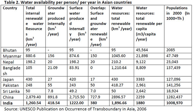
The development of groundwater has increased in the past 30 years. The ratio of groundwater abstraction with mean recharge is done at the country level. There are many areas where the over-abstraction of groundwater occurs at the provincial level. Groundwater is crucial for human drinking and food security, especially in developing countries. The impact of groundwater use is positive and includes benefits such as increased productivity, food security, job creation, livelihood diversification and general economic and social improvement. In the long run, the impact of groundwater extraction might be negative especially in overexploitation situations, such as the permanent lowering of the water table, deterioration of water quality and saline intrusion in coastal areas. The social and economic dimensions of groundwater use as well as its benefits are important for development in Asia. The water availability per person/per year in Asian Countries are given in Table-2
 Groundwater irrigation has also ensured security and helps alleviate poverty. For example, in India, the population increased quickly in the last 20 years, and it has a promising grain reserve of over 60 million tons and annual grain production touched a record high of 210 million tons in 2002-2003. Similarly, Bangladesh, dependent on foreign aid for a long time, had sufficient food supply in 1999-2000, and it was due to groundwater irrigation. Groundwater irrigation, especially in water abundant areas such as the eastern part of India, Bangladesh and Nepal can be an effective way to alleviate poverty. Since the 1970s, groundwater extraction has increased greatly in China, India, Republic of Korea and some other countries in South Asia.
CONCLUSION
North Eastern Region, though endowed with high rainfall, suffers from water shortage during the dry months particularly in hilly areas. As the incidence of rainfall is high, rainwater is considered to be a viable means to augment the water supply for domestic water needs. A perusal of long term water level trends indicated that there is no decline in water levels. Further the ground water development is also meager. On the other hand the scenario in hilly areas is different.
The average annual flow of Brahmaputra River is over 50 million hectre metre as measured at Pandu, Guwahati which is one-third of India’s total surface water flow. This enormous potential is not required within the Assam valley or for that matter even within the neighboring country like Bangladesh. If proper storage of such monsoon flow in the region could be arranged in the hilly terrains of Arunachal Pradesh, with proper management of artificial recharge to ground water by constructing appropriate structures with arrangement for releases from the reservoirs, the water will not only meet the entire need for irrigation and drinking water supply of the states of Arunachal Pradesh, Assam and its neighboring states but will have enough to spare for other water short areas of India, without adversely affecting the interest of Bangladesh, who must be provided their requirement as per international norms.
The storage of water will increase the dry weather flow and depth of flow contributing to perennial river system and accessibility for irrigation and other domestic activities. As far as the trasboundary development of the Brahmaputra River system is concerned, the precious waters of this river should not go waste due to our laxity of policymakers and experts.
Groundwater demands and dependent environmental problems are driving forces for hydrogeologists. There are so many issues that need to be resolved.
- The main tasks are the assurance of groundwater for the livelihoods and food security of millions of people, the ustainable use of groundwater for sustainable socio – economic development, effective management of groundwater.
- The groundwater monitoring, dynamic assessment and groundwater dependent ecosystems conservation are the major ways to address these issues.
- Greater knowledge and the improvement of basic data through research are prerequisites for better management of groundwater systems.
- There is an urgent need for expansion in the knowledge of user and institutional perspectives in the groundwater knowledge base.
- It is necessary to have an integrated management of both surface and groundwater resources. Therefore, it can be seen that the benefits of groundwater have considerable impact in Asia and Indian sub-continent.
- The key challenge for hydrogeologists is to devise ways and means of reducing the adverse impacts of groundwater use without significantly reducing benefits. In this context, hydrogeologists have an important role to act in providing updated data and analyses that will help decision-makers in formulating implementable and socially acceptable policy responses.
REFERENCES
- Aditi Mukherji & Tushaar Shah, 2005, Groundwater Socio-ecology and Governance: A review of institutions and policies in selected countries, Hydrogeology Journal (2005) 13:328-345
- Central Ground Water Board, Report of the Ground Water Resource Estimation Committee, Ground Water Resource Estimation Methodology -1997 (GEC'97)
- Geological Survey of India (1974). Geology and Mineral Resources of the States of India. Pt.IV. Misc. Pub.No.30
- International Association of Hydrogeologists (IAH). 2003. World Hydrogeological Map. IAH Commission on Mapping. http://www.iah.org.
- Institute of Hydrogeology and Engineering Geology, Chinese Academy of Geological Sciences, 1996, Hydrogeological Map of Asia 1:8 M, Geological Publishing House, Beijing, China
- Igor S. Zektser, Lorne G. Everett, 2004, Groundwater Resources of the World and their Use, UNESCO IHP-VI, Series on Groundwater No.6
- Karanth, K. R. (1987) Ground Water Assessment – Development and Management; Tata Mc Graw-Hill Pub.; New Delhi; 720 P.
- Krishnan, M.S.(91982) Geology of India and Burma: 6th Ed.:CBS Pub.: New Delhi:536 P
- Puri, S. 2003. Transboundary aquifers: International water law & hydrogeological uncertainty. Water International, IWRA 28, no. 2: 276–279.
- Todd, D. K. (1959) Ground Water Hydrology; 4th Ed.; John Willy and Sons Inc.; N.Y.; 535 P
- UNESCO (2008). Groundwater Resources of the World: Transboundary Aquifer Systems (Map).Worldwide Hydrogeological Mapping and Assessment Programme. Hannover, Paris: NESCO/IHP.
- UNESCO, 2003, World water Development Report: Water for People, Water for life, UNESCO and Berghahn Book, Barcelona
- United Nations, 2006, Water:A Shared Responsibility, the United Nations World Water Development Report 2, 2006.3,http://www.unesco.org/publishing
- UN, Water Resources Development in Asia and the Pacific Some Issues and Concerns//Water Resources Series, New York:1987, No.62
- UN, Groundwater in Continental Asia (Central, Eastern, Southern, South-eastern Asia)//Natural Resources/Water Series, New York:1986
G.C.Saha
Regional Director(Retd), Central Ground Water Board
S.Somarendro Singh
Scientist, Central Ground Water Board, Guwahati
Posted by


