


INTRODUCTION
Water is an essential commodity for living world. Nature has distributed this precious resource depending on geomorphology, geo-formations and climate etc of the area. Human being has however divided the resources by putting International boundary across this wealth of the nature. The world’s 263 transboundary lake, river basins & aquifer systems include the territory of 145 countries and cover nearly half of the Earth’s land surface.
Over the last 60 years there have been more than 200 international water agreements and only 37 cases of reported violence between States over water. We need to develop opportunities for cooperation that transboundary water management can provide for current and future generations. It is cooperation and not conflicts which can bear the fruits of efficient water management across the globe. It is understood that the opportunities for cooperation in transboundary water management can help to build mutual respect, understanding and trust among countries and promote peace, security and sustainable economic growth. Whether, we are on upstream or downstream of same drainage, we should treat ourselves on the same boat and needs to develop cohesive & coordinated approach of water management across the International boundaries. Indian States sharing International Boundary with Pakistan include Jammu & Kashmir Punjab, Rajasthan and Gujarat.
GENERAL INFORMATION
Districts of Rajasthan Sharing International Boundary with Pakistan are Ganganagar, Bikaner, Jaisalmer, and Barmer having total length in Rajasthan of the tune of 1070 Km (Fig 1). Sindh and Punjab are adjoining Provinces of Pakistan adjacent of Rajasthan State.
The terrain along border is rugged and inaccessible due to loose sand dunes and less road network. The border area is mostly barren and thinly populated. Geomorphologically, Thar desert is having landscapes of various types of dunes and inter-dunal depressions in major parts. Arid climate prevails in the transboundary area having even less than 200mm average annual rainfall. Rainfall is highly variable, irregular & erratic and the area is reeled under frequent droughts spells of 2 - 3 years durations. In India, the trasboundary area is drained by the Ghaggar river while in Pakistan Indus, Jhelum, Chenab, Ravi, Vyas and Sutlaj drains the area.(Fig-2a &b) A large area of western Rajasthan and adjoining Pakistan has no natural drainage due to duny nature of terrain and low rainfall.
 A network of irrigation canals exist since pre-independence times in Pakistan. On Indian side Indira Gandhi Nahar almost runs parallel to the border in Ganganagar, Bikaner and Jaisalmer districts. The canal system in India and Pakistan is shown in Fig 3a and 3b respectively.
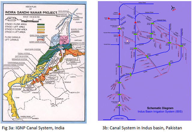
GEOLOGY
Geologically the area comprises of pre-cambrian granites and rhyolites, Lathi, Jaisalmer, Baisakhi and Badesar formation of Jurrassic age, Sanu, Khuiala, Banda, Akli, Kapurdih formation of Palaceocene – Ecocene age, alluvium and aeolian sand of quaternary age. The geological succession in Western Rajasthan is as follows in Table-I
 The geological section of western Rajasthan in Ganganagar and Bikaner districts has been represented in the fig 4.
HYDROGEOLOGY
 International Hydrologic Programme (IHP) launched Internationally Shared Aquifer Resources Management (ISARM) project to evaluate world’s transboundary aquifer systems. However, the available information reveals that Quaternary alluvium and aeolian sediments consisting of sand, silt, clay, kankar form aquifers in major parts of the transboundary areas (Fig 5) while Tertiaries also form aquifers in Barmer district (Fig 6). Successive Pre-Quaternary aquifers occur towards Aravalli hills in Rajasthan and towards Baluchistan Plateau in Pakistan. Depth to water levels widely varies from 5m in canal command areas to over 100 m below ground level(bgl) in other areas.
Semi-Consolidated Formations:
Tertiary formation sediments are predominately argillaceous consisting of fine grained sandstone, limestone shales, clay, fullers earth and gypsum. Tertiary formation consists of alternate layers of clay and shales associated with fullers earth & bentonitic clay which are unproductive. The major part of the formation contains saline ground water. Tertiary sandstone form potential aquifer in Girab-Gadra–Khaniyani area of Barmer district and Sanu-Khuiyala area of Jaisalmer district. Depth to water level varies from 60 mbgl to more than 80 mbgl. Yield of the formation generally is less than 10 litres per second(lps).

Unconsolidated Formation:
The quaternary sediments comprising unconsolidated aeolian and alluvium are the important formations due to their wide spread occurrence. The sediments are composed of sand. silt, clay gravel, calcareous and ferruginous concretions and occur in northern, western and southern part of the area. Sand, gravel and admixture of these form fairly thick, extensive, discontinuous potential aquifer in southern part of Barmer district. However, a major part of alluvium contains saline ground water. The Ground water occurs under unconfined to confined conditions down to depth of 330 m. Depth to water level varies from less than 10 mbgl. to more than 60 mbgl. and become shallower towards the Luni river. Yield of the wells is generally less than 10 lps in this formation.
Depth To Water Level
Depth to water in the area varies largely from less than 10 to more than 100 m. bgl. However, over a major part of the area it varies from 20 m to > 60 mbgl. Deep water levels are observed in the Sam Block of Jaisalmer district, Sheo & Chohatan Block of Barmer district of Rajasthan.
Artesian Conditions in Thar Desert, Rajasthan
In the Thar desert , Jaisalmer is particularly known as drought prone district of the Region. There is scarcity of drinking water throughout the year. The area has inherent groundwater salinity in the upper aquifers and is occupied by thick pile of Tertiary and Quaternary sediments.
Central Ground Water Board has drilled an exploratory bore hole up to a depth of 202 m bgl at Jaluwala in Jaisalmer district close to international border. On the basis of the lithological and electrical log of the bore hole one promising granular zone has been demarcated at the depth of 180 m bgl under the upper saline ground water aquifers. Below the depth of this saline zone, in between 180 m to 198 mbgl, relatively fresh water was encountered with free flowing conditions. The flow of artesian well is 180 liters per minute, making available relatively the fresh water (potable) without lifting cost. Discovery of the artesian wells in desert is a important scientific achievement of the Central Ground Water Board. The fresh ground water is occurring under artesian conditions below the saline groundwater aquifers due to presence of confined beds of grey shales. The artesian aquifer comprises of coarse grained gravelly sandstone of Tertiary age.
In Pakistan also, Quaternary alluvium is the main aquifer system . Ground water flow is by and large westerly i.e. subsurface water from India is flowing towards Pakistan. The overall flow of subsurface water in Indus basin is southwestwardly. Quality of ground water is mostly saline on either side of the International boundary.
GROUND WATER QUALITY
 In the area adjoining to international boundary along Rajasthan state, the EC ranges generally varying from 3000 to 10000 micro- mhos/cm and even higher. Groundwater development is not taking place significantly due to salinity, rugged terrain, low population density and availability of canal network on either side of the International border. Water logging is also taking place on both sides of border due to intensive irrigation in canal command areas. Ground water of fresh quality also occurs in pocket areas along the length &
ORIGIN OF A FRESH GROUND WATER BODY IN CHOLISTAN, THAR DESERT,PAKISTAN
Cholistan is the largest of four major deserts of Pakistan (Fig.8). It is bordered on the south by the Thar desert in Sindh province and on the east by the Rajasthan desert in India. The Cholistan desert covers about 26,000 km2 which corresponds to 26% of the 110,000 km2 of the country’s total desert area and 3% of its overall surface area.
The Thar Desert of Pakistan stretches along the border to India and is one of the most densely populated deserts in the world. Brackish to saline groundwater prevails. A locally restricted fresh groundwater resource was discovered by a comprehensive hydrogeological, geophysical, and isotope hydrological survey conducted from 1986 to 1991. The origin, recharge mechanism and age of the fresh groundwater resource were assessed. There is only fossil groundwater and this must be mined. Sodium is the predominant cation. Present groundwater recharge is absent or extremely low as the annual precipitation rate and the potential evapotranspiration rate amount to less than 200 mm/yr and about 2700 mm/yr, respectively. The results of this study delivered a hydrogeological concept on the origin and recharge of the fresh groundwater body. We found that the fresh groundwater was indirectly recharged during flash floods in low lands during the last pluvial period rather than directly replenished in the high mountain areas far in the east.
Hydrogeological Setting
The 18-Q m line of the apparent resistivity, related to 50 m depth below the surface comprises a 14 km wide and 98 km long strip. It traces a fresh groundwater body directed from east to southwest as the Old Hakra River (Fig. 9 &10). This apparent resistivity corresponds to an electrical conductivity of groundwater of less than 1500 S/cm corresponding to 900-1200 mg/litre (Ploethner, 1992). The average fresh groundwater saturated aquifer thickness is about 100 m; the total volume comes to 10 km3, which is almost completely embedded by brackish to saline groundwater. The electrical conductivity of the latter varies from up to 3400 at the top to 29000 S/ cm at a depth of 100 m, and 52000 S/ cm in the east.
 (The former bed of the Old Hakra River is surrounded by circles. Hatched area is the extention of the fresh ground water resources, shifted to the south)
 The fluvial sediments consist of slightly calcareous and micaceous fine grained sands, covered and interbedded by sandy-silty clays. This setting is a typical semiconfined aquifer system. The total porosity was found by grain size analysis to be 40%, while the effective porosity, is assumed to be 15% (Ploethner, 1992). The unconsolidated sediments explored by drillings down to 500 m consist of medium to coarse-grained sands below about 100 m. The hydraulic gradient, D, from east to southwest is about 0.3%. The hydrochemistry of the fresh groundwater is of the Na-HCO3 or Na-HCO3-Cl type. It changes from Na-Cl-HC03 and Na-Cl-S04 towards the Na-Cl type with increasing depth and salinity.
The fresh groundwater meets the chemical standards laid down for drinking water. however, its suitability for irrigation purposes is limited due to the high proportion of sodium. The isotope hydrological study is needed to prove the occurrence of present-day recharge of the fresh groundwater resources occurs.
GROUNDWATER DEVELOPMENT IN RAJASTHAN
Ganganagar District- Tube wells of 30-70m depth tapping shallow unconfined aquifer have been developed with medium yield. In Ghaggar bed area, shallow tube wells up to 40m depth with moderate yields are in use. Native groundwater is saline in the district.
Bikaner District- The alluvial aquifer in bordering area is mostly saline with meager groundwater development.
Jaisalmer District- In northern part, alluvial aquifer are mostly saline with meager groundwater development. In NW corner of the district, alluvial aquifer is in limited patches at Kishangarh, Dharmi Khu, Ranau, Ghotaru area is fresh, however overall native quality is brackish to saline. Groundwater development is negligible due to scarce population and barren dunes.
Barmer District- In North Western part Tertiary aquifer in Sundra-Gadra area has better quality of water under unconfined to confined conditions. Alluvial & Tertiary aquifers in other parts have brackish to saline groundwater and tapped by tube wells for domestic/cattle uses.
CONCLUSION
- The long border of Rajasthan with Pakistan is mainly occupied by alluvial aquifer having native saline to highly saline groundwater.
- The underlying Tertiary formation also have saline groundwater with meager to moderate groundwater potential.
- Alluvial and tertiary aquifers of Barmer district have brackish to saline groundwater with isolated patches of better quality groundwater.
- In Pakistan part adjoining to Indian border, alluvium forms the principal aquifer. The quality is largely saline. Fresh water is found in small pockets and along some inferred paleo- channel courses.
- A network of irrigation canals exist since pre-independence times.
- Ground water development is very low due to saline ground water, rugged terrain, low population density and canal network in bordering areas.
RECOMMENDATIONS
- Fresh Groundwater development can be enhanced in Ghaggar bed area to utilize sub-surface flow going out across the border.
- Shallow freshwater cushion developed along IGNP canal can be tapped through shallow skimming wells, so as to prevent its westward dissipation. Conjunctive use of surface and ground water will also avoid water logging and salinity hazards in the vicinity of canal command areas.
- Canal water thus saved can be utilized in tailend/down stream areas of IGNP.
- Comparatively better quality groundwater is available in Sundra & Gadra of Barmer districts, which can be further developed for regional drinking water supply schemes in adjoining saline desert areas.
- Fresh Groundwater found in Kishangarh, Kuria Beri, Ghotaru & Ranau area in Jaisalmer cannot be utilized presently because of little settlements.
- Mutual trust and conducive relationship is pre-requisite between India and Pakistan for joint assessment and management of Trans- boundary water especially to tap aquifer systems for mutual benefits.
REFERENCES
- M. A. Geyh & D. Ploethner: Origin of a fresh groundwater body in Cholistan, Thar Desert, Pakistan.
- M. A. Geyh & D. Ploethner : An applied palaeohydrological study in Cholistan, Thar Desert, Pakistan
- Case Study Volume: Pakistan: The Cholistan desert: facing the challenges, World Water Development Report 3.
- Central Ground Water Board Western Region, Reports.
Manoj Srivastava
Regional Director, Central Ground Water Board, Jaipur
O.P.PooniaScientist, Central Ground Water Board, Jaipur
Posted by


