


ABSTRACT
The Palla well field of Delhi is a model of sustainable groundwater development and management practices. A battery of ninety tubewells extracts around 25-30 MGD (41-49 million m3/day) of groundwater to augment drinking water needs of Delhi. The groundwater management policy for groundwater abstraction from the well field was based on a numerical modeling study. The paper explains details of numerical modeling studyand critically examines the model. It suggests for updating of the numerical model used for formulating groundwater management policy in the Palla well field of Delhi.
INTRODUCTION
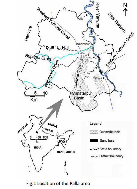
The NCT of Delhi has perennial deficit of drinking water, mainly attributed to the ever increasing population of Delhi. The drinking water deficit in Delhi can be partially augmented by developing the potential aquifers. The aquifers in Yamuna flood plain of NCT Delhi is most promising aquifer for development of the groundwater resources. Palla area (Fig.1) lies in the part of the flood plain of river Yamuna and nearly ninety tubewells were constructed there for augmenting drinking water supply to NCT Delhi. The Yamuna flood plain aquifers in Palla area has considerable freshwater thickness in range of 35 to more than 65 meters. The Yamuna river in this stretch has no visible major drains joining it as such it is pollution free, or else there are nearly 19 drains joining river Yamuna downstream. The active flood plain in the area is totally agricultural land and it gets flooded during post monsoon inundation by river Yamuna leading to natural recharge to subsurface aquifers by surface spreading methods during peak post monsoon floods.
HYDROGEOLOGY
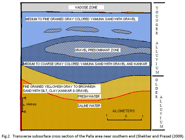
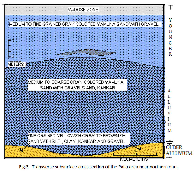
The Yamuna flood plain of Palla area has younger alluvium overlying older alluvium. The younger alluvium comprises of medium to coarse sand admixed with silt, clay and heterogeneously coloured gravels (Fig.2 and Fig.3). They have been classified as unconfined aquifers (Shekhar and Prasad 2009; Shekhar 2006; Rao et al 2007). Whilethe older alluvium is composed of finer sediments having clay admixed with silt and kankar (calcareous concretions). The saline water is mostly restricted to older alluvium. The depth to water level in the area is found in the range of 5 m below ground level. The transmissivity of the younger alluvium is in the range of 600-2000 m2/day, while transmissivity ofthe older alluvium is in the range of 130-403 m2/day (Shekhar et al 2009, Chatterjee et al 2009). The Specific yield of the aquifer is in the range of 0.2. The average discharge from individual tubewells in the Palla area was in the range of 0.5 MGD (0.82 million m2/day) and as such it was expected to have around 45 MGD (74 million m2/day) of groundwaterdischarge from a battery of 90 tubewells in Palla area. The quality of groundwater from the battery of tubewells was well within the desirable limit set for drinking water.
THE GROUNDWATER MODELING IN THE PALLA AREA
The production from the Palla well field tubewells raised many issues which needed to be addressed scientifically. Some of the issues raised by different stake holders are listed below:
1. Such high density of tubwells will lead to very high discharge from a very small area, which may lead to saline water up coning from the lower saline aquifers.
2. The shallow tubewells of the farmers in the area will become non functional by lowering of the water table during peak discharge period
3. The heavy withdrawal of groundwater from close vicinity of the river will alter the river flow, which may be in contradiction to the river water sharing agreement between the riparian states.
The above raised issues could not be addressed by analytical solutions or numerical techniques. It required that a system simulation and numerical modeling study be done and the issues addressed in right perspective. In this perspective a collaborative project between NIH Roorkee and Central Ground Water Board was formulated. The project had time span of one year to finish the work on priority basis. It was decided by the project investigators that the first model of the area should address the issue of saline water up coning and suggest optimal pumping schedule to control saline water up coning and see that water level lowering during peak demand period does not affects the shallow tubewells of the farmers. The issue of stream aquifer interaction was not the main objective in the model, though a subjective quantification on stream aquifer interaction would always be a product of any such modeling exercise. This was decided primarily because the rivers cross sections, time series river gauge and discharge data and other hydrological data related to the river Yamuna was not available. In order to overcome the data limitation, the Yamuna stretch in the model area was surveyed locally to provide the minimum necessary data for the numerical modeling exercise. Thus it was agreed that the stream aquifer interaction produced by such models will not be very accurate but a subjective figure. In the context of very short duration of time available for the study, the project investigators agreed that only spatial model calibration will be done and temporal calibration of the model with water level hydrograph at the groundwater monitoring stations in the model area will be taken up later, during subsequent study on the issue.
The model area:
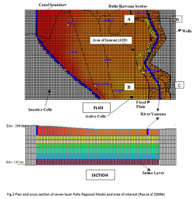
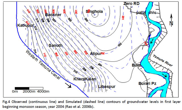
The area of interest was only a small area in the flood plain where these battery of tubewells were installed, but due to unavailability of suitable boundary conditions, the model area was extended further in west to coincide with the western Yamuna canal which in turn coincided with hydraulic boundary (Fig.3 and Fig.4). It was decided that a telescopic mess refinement will be done for the area of interest and thus regional to local approach of numerical modeling was adopted.
The model structure:
A seven layer model was designed with 53 rows and 99 columns with grid spacing in X and Y direction as 250 meter for the regional model. The surface topography was superimposed on the top layer. The spacing in the z direction varied from 10-25 meters. A no flow boundary was set at around 85-100 meter below ground level in the seventh layer.
The input and output stresses:
The input stress was uniform rainfall recharge of 0.1 meter per monsoon season and recharge of 0.3 to 0.5 meters from the flood water during the floods (Rao et al 2007) and the output stress was the groundwater discharge figures extrapolated from CGWB report Chatterjee et al (2006) subsequently published in paper Chatterjee et al (2009), the groundwater extraction figures in the area of interest was further verified by wellinventory in field.
The aquifer parameters in the model:
The modeling exercise was started with the aquifer parameters established by aquifer performance tests in field, and the concept paper of the study Rao et al (2006a) had taken the hydraulic conductivity of the formation in X and Y direction as 45 m/day and in Z direction as 4.5 m/day. It was felt during the course of modeling exercise that the aquifer parameters were not giving realistic results; hence inverse modeling approach was used to derive the appropriate aquifer parameter values. The aquifer parameters ultimately used in the model (Rao et 2007 ) considered the aquifer heterogeneity and assumed hydraulic conductivity of 20 m/day in the first layer of the model, and hydraulic conductivity of 9.8 m/day in x and y direction and 1 m/day in Z direction in the remaining layers of the model. The specific yield was assumed as 0.2.
The Model outputs:
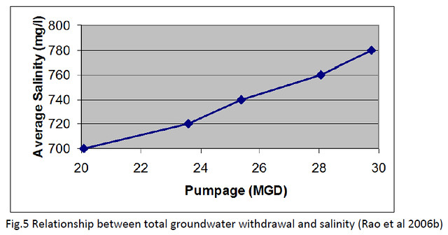
The model generated heads were contoured and matched with contour of the water table heads observed on regional scale and then different scenarios were created (Fig.4). The model output was optimized to see the relationship between salinity and total groundwater draft from the well field (Fig.5).
The model suggested optimum pumping schedule from the Palla group of tubewells to control the possibility of saline water up coning. It was suggested that the Palla well field can sustainably supply 25-30 MGD (41-49 million m3/day) of drinking water by staggering pumping in space and time. This meets 20% of Delhi’s drinking water deficit. It was also established that the Palla well field seeks to pump groundwater that is seasonallyrecharged by floodwaters in the flood plains and from the river boundary. The water quantity pumped through the Palla well field has approximately 40% contribution from rainfall and induced flood recharge, 38% contribution from river boundary recharge and 22% contribution from aquifer storage. It can be said that the Palla well field pumping creates additional subsurface storage space. If the abstraction does not create a space for absorbing the flood recharge, the flood recharge water would invariably join the river boundary or cancreate water logging conditions. Thus the Palla Well field helps in utilizing flood recharge more efficiently.
DISCUSSIONS
The groundwater model produced by the collaboration between NIH Roorkee and CGWB published in Rao et al 2007 needs to be updated. As mentioned earlier, the model had only spatial calibration, thus it is required to have temporal calibration with water level hydrographs over a period of time. The model also needs to be updated by incorporating time series hydrological data related to river Yamuna and western Yamuna Canal. Itis suggested to incorporate salinity gradient data collected from the aquifers in the area in to the model to the extent possible. The input stress in the Palla model published in Rao et al 2007 included recharge by flood waters during the flood. It is suggested to have an assessment of surface spreading of the flood waters (inundation pattern) in the model area at the different stages of water flow in the river Yamuna and incorporate that as input in the revised model. The aquifer parameters inferred in the model using inverse modeling approach also needs to be re assessed vis-à-vis aquifer geometry and if required then some suitably designed aquifer performance test can be done. The lateral and vertical aquifer heterogeneity needs to be refined in the model with respect to hydraulic conductivity and storage coefficient. The revised Palla model then can be run to give maximum possible sustainable groundwater extraction from the area with various permutation and combination of tubewell spacing and tubewell locations. The groundwater recharge variations in wet and draught years must also be taken in to consideration. To sum up it is suggested to havethe revised model peer reviewed by active workers in the field and the model parameters, input and output stresses etc. agreed upon by all the concerned stake holders.
REFERENCES
- Chatterjee Rana, Gupta B K, Mohiddin S K, Singh P N and Shekhar Shashank, 2006. Ground Water Resources of National Capital Territory , Delhi. Report, Central Ground Water Board, Delhi, Ministry of Water Resources, Government of India.
- Chatterjee, Rana, Gupta B K, Mohiddin S K, Singh P N, Shekhar Shashank and Purohit Rajaram, 2009. Dynamic groundwater resources of National Capital Territory, Delhi: assessment, development and management Options. Environ Earth Sci J. 59(3): 669-686.
- Rao, S V N, Kumar Sudhir, Shekhar Shashank, Sinha S K and Manju S, 2007. Optimal pumping from Skimming Wells from the Yamuna river flood plain in north India. Hydrogeology J. 15(6): 1157-1167.
- Rao, S V N, Kumar Sudhir, Shekhar Shashank and Chakraborti D, 2006a. Optimum pumping from Skimming Wells. Journal of Hydrologic Engineering. 11(5): 464-471.
- Rao S V N , Kumar Sudheer , Sinha S.K and Shekhar Shashank, 2006b. An operational model for groundwater pumping at Palla Well Fields, NCT, Delhi. Project Report of a joint study by National Institute of Hydrology, Roorkee and Central Ground Water Board, New Delhi.
- Shekhar, Shashank and Prasad R K, 2009. The groundwater in Yamuna flood plain of Delhi (India) and the management options. Hydrogeology J. 17(7): 1557-1560.
- Shekhar, Shashank, 2006. An approach to interpretation of Step Drawdown Tests. Hydrogeology J. 14(6): 1018-1027.
- Shekhar, Shashank, Purohit Raja Ram and Kaushik Y B, 2009. Groundwater Management in NCT Delhi. In proceedings 5th Asian Regional Conference of Indian National Committee on Irrigation and Drainage (INCID), December 9-11, 2009, Vigyan Bhawan, New Delhi. Paper available on website: http://cgwb.gov.in/documents/papers/INCID.html
Shashank Shekhar and S V N Rao
Department of Geology, University of Delhi
Water and Power Consultancy Services (WAPCOS)
Posted by


